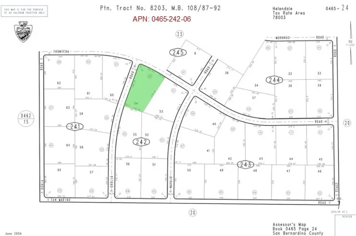
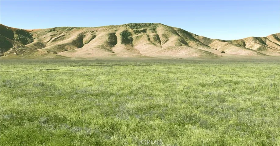
array:2 [ "RF Query: /Property?$select=ALL&$orderby=ListPrice DESC&$top=12&$skip=91908&$filter=(StandardStatus in ('Active','Active Under Contract')) and (PropertyType eq 'Residential' OR PropertyType eq 'Land' OR PropertyType eq 'Business Opportunity' OR PropertyType eq 'Commercial Sale' OR PropertyType eq 'Residential Income')/Property?$select=ALL&$orderby=ListPrice DESC&$top=12&$skip=91908&$filter=(StandardStatus in ('Active','Active Under Contract')) and (PropertyType eq 'Residential' OR PropertyType eq 'Land' OR PropertyType eq 'Business Opportunity' OR PropertyType eq 'Commercial Sale' OR PropertyType eq 'Residential Income')&$expand=Media/Property?$select=ALL&$orderby=ListPrice DESC&$top=12&$skip=91908&$filter=(StandardStatus in ('Active','Active Under Contract')) and (PropertyType eq 'Residential' OR PropertyType eq 'Land' OR PropertyType eq 'Business Opportunity' OR PropertyType eq 'Commercial Sale' OR PropertyType eq 'Residential Income')/Property?$select=ALL&$orderby=ListPrice DESC&$top=12&$skip=91908&$filter=(StandardStatus in ('Active','Active Under Contract')) and (PropertyType eq 'Residential' OR PropertyType eq 'Land' OR PropertyType eq 'Business Opportunity' OR PropertyType eq 'Commercial Sale' OR PropertyType eq 'Residential Income')&$expand=Media&$count=true" => array:2 [ "RF Response" => Realtyna\MlsOnTheFly\Components\CloudPost\SubComponents\RFClient\SDK\RF\RFResponse {#7613 +items: array:12 [ 0 => Realtyna\MlsOnTheFly\Components\CloudPost\SubComponents\RFClient\SDK\RF\Entities\RFProperty {#7622 +post_id: "44922" +post_author: 1 +"ListingKey": "1104294932" +"ListingId": "HD25026293" +"PropertyType": "Land" +"StandardStatus": "Active" +"ModificationTimestamp": "2025-06-11T04:33:15Z" +"RFModificationTimestamp": "2025-06-11T04:56:18.156980+00:00" +"ListPrice": 16950.0 +"BathroomsTotalInteger": 0 +"BathroomsHalf": 0 +"BedroomsTotal": 0 +"LotSizeArea": 217800.0 +"LivingArea": 0 +"BuildingAreaTotal": 0 +"City": "Lucerne Valley" +"PostalCode": "92356" +"UnparsedAddress": "0 Emerald, Lucerne Valley, California 92356" +"Coordinates": array:2 [ 0 => -116.988073 1 => 34.400417 ] +"Latitude": 34.400417 +"Longitude": -116.988073 +"YearBuilt": 0 +"InternetAddressDisplayYN": true +"FeedTypes": "IDX" +"ListAgentFullName": "Brandi Olson" +"ListOfficeName": "CENTURY 21 Rose Realty" +"ListAgentMlsId": "HD22318" +"ListOfficeMlsId": "HD1807" +"OriginatingSystemName": "CRMLS" +"PublicRemarks": "Motivated Seller! This property offers breathtaking panoramic vistas within the embrace of Lucerne Valley's rolling hills. This property offers an unrivaled opportunity, with close proximity to Apple Valley, Victorville, Hesperia, and the captivating Big Bear community. A sprawling 5-acre canvas awaits your vision, it holds a 192 sq ft. foundation slab that echoes the memory of a 1957 miners cabin that once graced this land but has since made way for new possibilities. Whether you envision an off-grid retreat or an enchanting Airbnb escape, the potential here is limitless. 10 minutes to locally famous Johnson Valley OHV! Less than a 30-minute drive and you are in the mountains of the San Bernardino National Forest, with access to Big Bear Lake water recreation, camping,hiking, and much more. There may be potential to Subdivide" +"CommonInterest": "None" +"CommunityFeatures": "Foothills,Hiking,Horse Trails,Mountainous,Near National Forest,Preserve/Public Land,Rural" +"ContractStatusChangeDate": "2025-02-03" +"Country": "US" +"CountyOrParish": "San Bernardino" +"CreationDate": "2025-02-05T05:46:03.703085+00:00" +"CumulativeDaysOnMarket": 1119 +"CurrentUse": "Recreational" +"DaysOnMarket": 159 +"DaysOnMarketReplication": 126 +"DaysOnMarketReplicationDate": "2025-06-11" +"DaysOnMarketReplicationIncreasingYN": true +"Directions": "Head east on CA-18 toward Custer Ave 135 ft Turn right onto Custer Ave 2.1 mi Turn right onto Buenos Aires Rd 0.5 mi Turn left onto Banta Rd 0.2 mi Slight left at Buena Vista Rd" +"DistanceToWaterComments": "n/a" +"ElevationUnits": "Feet" +"HorseAmenities": "Riding Trail" +"HorseYN": true +"RFTransactionType": "For Sale" +"InternetAutomatedValuationDisplayYN": true +"InternetConsumerCommentYN": true +"InternetEntireListingDisplayYN": true +"ListAgentAOR": "High Desert" +"ListAgentEmail": "Brandi.Sells.Socal@gmail.com" +"ListAgentFirstName": "Brandi" +"ListAgentKey": "19462528" +"ListAgentKeyNumeric": "19462528" +"ListAgentLastName": "Olson" +"ListAgentOfficePhone": "760-244-5481" +"ListAgentStateLicense": "02155222" +"ListAgentURL": "https://brandisellssocal.com/" +"ListOfficeAOR": "High Desert" +"ListOfficeEmail": "michael.knight@century21.com" +"ListOfficeFax": "760-244-5051" +"ListOfficeKey": "3267497" +"ListOfficeKeyNumeric": "3267497" +"ListOfficePhone": "760-244-5481" +"ListOfficeURL": "http://www.century21roserealty.com" +"ListingAgreement": "Exclusive Right To Sell" +"ListingContractDate": "2025-02-03" +"ListingKeyNumeric": 1104294932 +"ListingService": "Full Service" +"ListingTerms": "Cash" +"LotFeatures": "Bluff,Horse Property,Lot Over 40000 Sqft,Rectangular Lot,Ranch,Secluded,Value In Land" +"LotSizeAcres": 5.0 +"LotSizeSource": "Assessor" +"LotSizeSquareFeet": 217800.0 +"MLSAreaMajor": "LUV - Lucerne Valley" +"MajorChangeTimestamp": "2025-06-10T14:01:05Z" +"MajorChangeType": "Price Change" +"MlsStatus": "Active" +"OnMarketDate": "2025-02-04" +"OnMarketTimestamp": "2025-02-04T20:27:33Z" +"OriginalEntryTimestamp": "2025-02-04T20:27:33Z" +"OriginalListPrice": 17000.0 +"OriginatingSystemID": "CRM" +"OriginatingSystemKey": "373896844" +"OriginatingSystemSubName": "CRMLS_CRM" +"ParcelNumber": "0451281320000" +"PhotosChangeTimestamp": "2025-02-05T04:59:41Z" +"PhotosCount": 6 +"PreviousListPrice": 17000.0 +"PriceChangeTimestamp": "2025-06-10T14:01:05Z" +"RoadFrontageType": "County Road" +"RoadSurfaceType": "Unimproved" +"Sewer": "Unknown" +"ShowingContactType": "Agent" +"SourceSystemID": "TRESTLE" +"SourceSystemKey": "1104294932" +"SpecialListingConditions": "Probate Listing" +"StateOrProvince": "CA" +"StatusChangeTimestamp": "2025-02-04T20:27:33Z" +"StreetName": "Emerald" +"StreetNumber": "0" +"UniversalPropertyId": "US-06071-N-0451281320000-R-N" +"Utilities": "None,Water Not Available" +"View": "City Lights,Canyon,Desert,Mountain(s),Panoramic,Valley" +"ViewYN": true +"WaterSource": "None" +"Zoning": "LV/RL-5" +"CustomFields": """ {\n "ProbateAuthority": "Court Confirmation Not Required",\n "AdminUpdateYN": "0",\n "ListingKey": "1104294932"\n } """ +"HumanModifiedYN": false +"LeaseAmountPerAreaUnit": "Dollars Per Square Foot" +"@odata.id": "https://api.realtyfeed.com/reso/odata/Property('1104294932')" +"CurrentPrice": 16950.0 +"provider_name": "CRMLS" +"RecordSignature": 815341099 +"UniversalParcelId": "urn:reso:upi:2.0:US:06071:0451281320000" +"CountrySubdivision": "06071" +"OriginatingSystemListOfficeKey": "361171941" +"OriginatingSystemListAgentMemberKey": "367191457" +"Media": array:6 [ 0 => array:58 [ "Order" => 1 "ImageOf" => null "ListAOR" => null "MediaKey" => "2003774302183" "MediaURL" => "https://dx41nk9nsacii.cloudfront.net/cdn/3/1104294932/7e67fcd3e36458954570e294682431b5.webp" "ClassName" => null "MediaHTML" => null "MediaSize" => 321323 "MediaType" => "webp" "Thumbnail" => "https://dx41nk9nsacii.cloudfront.net/cdn/3/1104294932/thumbnail-7e67fcd3e36458954570e294682431b5.webp" "ImageWidth" => null "Permission" => null "ImageHeight" => null "MediaStatus" => null "SyndicateTo" => null "ListAgentKey" => "19462528" "PropertyType" => "Land" "ResourceName" => "Property" "ListOfficeKey" => "3267497" "MediaCategory" => null "MediaObjectID" => "0.jpg" "OffMarketDate" => null "X_MediaStream" => null "SourceSystemID" => "TRESTLE" "StandardStatus" => "Active" "HumanModifiedYN" => false "ListOfficeMlsId" => "HD1807" "LongDescription" => null "MediaAlteration" => null "MediaKeyNumeric" => 2003774302183 "PropertySubType" => null "RecordSignature" => -308343711 "PreferredPhotoYN" => null "ResourceRecordID" => "HD25026293" "ShortDescription" => null "SourceSystemName" => null "ChangedByMemberID" => null "ListingPermission" => null "PermissionPrivate" => null "ResourceRecordKey" => "1104294932" "ChangedByMemberKey" => null "MediaClassification" => "PHOTO" "OriginatingSystemID" => "CRM" "ImageSizeDescription" => null "SourceSystemMediaKey" => null "ModificationTimestamp" => "2025-02-05T04:59:00.820-00:00" "OriginatingSystemName" => "CRMLS" "MediaStatusDescription" => null "OriginatingSystemSubName" => "CRMLS_CRM" "ResourceRecordKeyNumeric" => 1104294932 "ChangedByMemberKeyNumeric" => null "OriginatingSystemMediaKey" => "373896844" "PropertySubTypeAdditional" => null "MediaModificationTimestamp" => "2025-02-05T04:59:00.820-00:00" "SourceSystemResourceRecordKey" => null "InternetEntireListingDisplayYN" => true "OriginatingSystemResourceRecordId" => null "OriginatingSystemResourceRecordKey" => "373896844" ] 1 => array:58 [ "Order" => 2 "ImageOf" => null "ListAOR" => null "MediaKey" => "2003774302002" "MediaURL" => "https://dx41nk9nsacii.cloudfront.net/cdn/3/1104294932/b0137c6515619c2ce71d3ebc6f0bfbb5.webp" "ClassName" => null "MediaHTML" => null "MediaSize" => 313165 "MediaType" => "webp" "Thumbnail" => "https://dx41nk9nsacii.cloudfront.net/cdn/3/1104294932/thumbnail-b0137c6515619c2ce71d3ebc6f0bfbb5.webp" "ImageWidth" => null "Permission" => null "ImageHeight" => null "MediaStatus" => null "SyndicateTo" => null "ListAgentKey" => "19462528" "PropertyType" => "Land" "ResourceName" => "Property" "ListOfficeKey" => "3267497" "MediaCategory" => null "MediaObjectID" => "1.jpg" "OffMarketDate" => null "X_MediaStream" => null "SourceSystemID" => "TRESTLE" "StandardStatus" => "Active" "HumanModifiedYN" => false "ListOfficeMlsId" => "HD1807" "LongDescription" => null "MediaAlteration" => null "MediaKeyNumeric" => 2003774302002 "PropertySubType" => null "RecordSignature" => -335457695 "PreferredPhotoYN" => null "ResourceRecordID" => "HD25026293" "ShortDescription" => null "SourceSystemName" => null "ChangedByMemberID" => null "ListingPermission" => null "PermissionPrivate" => null "ResourceRecordKey" => "1104294932" "ChangedByMemberKey" => null "MediaClassification" => "PHOTO" "OriginatingSystemID" => "CRM" "ImageSizeDescription" => null "SourceSystemMediaKey" => null "ModificationTimestamp" => "2025-02-05T04:59:00.820-00:00" "OriginatingSystemName" => "CRMLS" "MediaStatusDescription" => null "OriginatingSystemSubName" => "CRMLS_CRM" "ResourceRecordKeyNumeric" => 1104294932 "ChangedByMemberKeyNumeric" => null "OriginatingSystemMediaKey" => "373896844" "PropertySubTypeAdditional" => null "MediaModificationTimestamp" => "2025-02-05T04:59:00.820-00:00" "SourceSystemResourceRecordKey" => null "InternetEntireListingDisplayYN" => true "OriginatingSystemResourceRecordId" => null "OriginatingSystemResourceRecordKey" => "373896844" ] 2 => array:58 [ "Order" => 3 "ImageOf" => null "ListAOR" => null "MediaKey" => "2003774302151" "MediaURL" => "https://dx41nk9nsacii.cloudfront.net/cdn/3/1104294932/38d09870a88ae41c9c0e7799cc99aafe.webp" "ClassName" => null "MediaHTML" => null "MediaSize" => 320779 "MediaType" => "webp" "Thumbnail" => "https://dx41nk9nsacii.cloudfront.net/cdn/3/1104294932/thumbnail-38d09870a88ae41c9c0e7799cc99aafe.webp" "ImageWidth" => null "Permission" => null "ImageHeight" => null "MediaStatus" => null "SyndicateTo" => null "ListAgentKey" => "19462528" "PropertyType" => "Land" "ResourceName" => "Property" "ListOfficeKey" => "3267497" "MediaCategory" => null "MediaObjectID" => "2.jpg" "OffMarketDate" => null "X_MediaStream" => null "SourceSystemID" => "TRESTLE" "StandardStatus" => "Active" "HumanModifiedYN" => false "ListOfficeMlsId" => "HD1807" "LongDescription" => null "MediaAlteration" => null "MediaKeyNumeric" => 2003774302151 "PropertySubType" => null "RecordSignature" => -308343711 "PreferredPhotoYN" => null "ResourceRecordID" => "HD25026293" "ShortDescription" => null "SourceSystemName" => null "ChangedByMemberID" => null "ListingPermission" => null "PermissionPrivate" => null "ResourceRecordKey" => "1104294932" "ChangedByMemberKey" => null "MediaClassification" => "PHOTO" "OriginatingSystemID" => "CRM" "ImageSizeDescription" => null "SourceSystemMediaKey" => null "ModificationTimestamp" => "2025-02-05T04:59:00.820-00:00" "OriginatingSystemName" => "CRMLS" "MediaStatusDescription" => null "OriginatingSystemSubName" => "CRMLS_CRM" "ResourceRecordKeyNumeric" => 1104294932 "ChangedByMemberKeyNumeric" => null "OriginatingSystemMediaKey" => "373896844" "PropertySubTypeAdditional" => null "MediaModificationTimestamp" => "2025-02-05T04:59:00.820-00:00" "SourceSystemResourceRecordKey" => null "InternetEntireListingDisplayYN" => true "OriginatingSystemResourceRecordId" => null "OriginatingSystemResourceRecordKey" => "373896844" ] 3 => array:58 [ "Order" => 4 "ImageOf" => null "ListAOR" => null "MediaKey" => "2003774302097" "MediaURL" => "https://dx41nk9nsacii.cloudfront.net/cdn/3/1104294932/b9ae37f629ce51f447524eeda50a9235.webp" "ClassName" => null "MediaHTML" => null "MediaSize" => 284062 "MediaType" => "webp" "Thumbnail" => "https://dx41nk9nsacii.cloudfront.net/cdn/3/1104294932/thumbnail-b9ae37f629ce51f447524eeda50a9235.webp" "ImageWidth" => null "Permission" => null "ImageHeight" => null "MediaStatus" => null "SyndicateTo" => null "ListAgentKey" => "19462528" "PropertyType" => "Land" "ResourceName" => "Property" "ListOfficeKey" => "3267497" "MediaCategory" => null "MediaObjectID" => "3.jpg" "OffMarketDate" => null "X_MediaStream" => null "SourceSystemID" => "TRESTLE" "StandardStatus" => "Active" "HumanModifiedYN" => false "ListOfficeMlsId" => "HD1807" "LongDescription" => "192 sqft. foundation from 1957 miners cabin" "MediaAlteration" => null "MediaKeyNumeric" => 2003774302097 "PropertySubType" => null "RecordSignature" => -308343711 "PreferredPhotoYN" => null "ResourceRecordID" => "HD25026293" "ShortDescription" => null "SourceSystemName" => null "ChangedByMemberID" => null "ListingPermission" => null "PermissionPrivate" => null "ResourceRecordKey" => "1104294932" "ChangedByMemberKey" => null "MediaClassification" => "PHOTO" "OriginatingSystemID" => "CRM" "ImageSizeDescription" => null "SourceSystemMediaKey" => null "ModificationTimestamp" => "2025-02-05T04:59:00.820-00:00" "OriginatingSystemName" => "CRMLS" "MediaStatusDescription" => null "OriginatingSystemSubName" => "CRMLS_CRM" "ResourceRecordKeyNumeric" => 1104294932 "ChangedByMemberKeyNumeric" => null "OriginatingSystemMediaKey" => "373896844" "PropertySubTypeAdditional" => null "MediaModificationTimestamp" => "2025-02-05T04:59:00.820-00:00" "SourceSystemResourceRecordKey" => null "InternetEntireListingDisplayYN" => true "OriginatingSystemResourceRecordId" => null "OriginatingSystemResourceRecordKey" => "373896844" ] 4 => array:58 [ "Order" => 5 "ImageOf" => null "ListAOR" => null "MediaKey" => "2003774302020" "MediaURL" => "https://dx41nk9nsacii.cloudfront.net/cdn/3/1104294932/a5b4ea93f7769cd7e6e0608a01b741a0.webp" "ClassName" => null "MediaHTML" => null "MediaSize" => 273973 "MediaType" => "webp" "Thumbnail" => "https://dx41nk9nsacii.cloudfront.net/cdn/3/1104294932/thumbnail-a5b4ea93f7769cd7e6e0608a01b741a0.webp" "ImageWidth" => null "Permission" => null "ImageHeight" => null "MediaStatus" => null "SyndicateTo" => null "ListAgentKey" => "19462528" "PropertyType" => "Land" "ResourceName" => "Property" "ListOfficeKey" => "3267497" "MediaCategory" => null "MediaObjectID" => "4.jpg" "OffMarketDate" => null "X_MediaStream" => null "SourceSystemID" => "TRESTLE" "StandardStatus" => "Active" "HumanModifiedYN" => false "ListOfficeMlsId" => "HD1807" "LongDescription" => null "MediaAlteration" => null "MediaKeyNumeric" => 2003774302020 "PropertySubType" => null "RecordSignature" => -335457695 "PreferredPhotoYN" => null "ResourceRecordID" => "HD25026293" "ShortDescription" => null "SourceSystemName" => null "ChangedByMemberID" => null "ListingPermission" => null "PermissionPrivate" => null "ResourceRecordKey" => "1104294932" "ChangedByMemberKey" => null "MediaClassification" => "PHOTO" "OriginatingSystemID" => "CRM" "ImageSizeDescription" => null "SourceSystemMediaKey" => null "ModificationTimestamp" => "2025-02-05T04:59:00.820-00:00" "OriginatingSystemName" => "CRMLS" "MediaStatusDescription" => null "OriginatingSystemSubName" => "CRMLS_CRM" "ResourceRecordKeyNumeric" => 1104294932 "ChangedByMemberKeyNumeric" => null "OriginatingSystemMediaKey" => "373896844" "PropertySubTypeAdditional" => null "MediaModificationTimestamp" => "2025-02-05T04:59:00.820-00:00" "SourceSystemResourceRecordKey" => null "InternetEntireListingDisplayYN" => true "OriginatingSystemResourceRecordId" => null "OriginatingSystemResourceRecordKey" => "373896844" ] 5 => array:58 [ "Order" => 6 "ImageOf" => null "ListAOR" => null "MediaKey" => "2003774302099" "MediaURL" => "https://dx41nk9nsacii.cloudfront.net/cdn/3/1104294932/fd9c7095c7887358bec3abc3cf3631d2.webp" "ClassName" => null "MediaHTML" => null "MediaSize" => 263498 "MediaType" => "webp" "Thumbnail" => "https://dx41nk9nsacii.cloudfront.net/cdn/3/1104294932/thumbnail-fd9c7095c7887358bec3abc3cf3631d2.webp" "ImageWidth" => null "Permission" => null "ImageHeight" => null "MediaStatus" => null "SyndicateTo" => null "ListAgentKey" => "19462528" "PropertyType" => "Land" "ResourceName" => "Property" "ListOfficeKey" => "3267497" "MediaCategory" => null "MediaObjectID" => "5.jpg" "OffMarketDate" => null "X_MediaStream" => null "SourceSystemID" => "TRESTLE" "StandardStatus" => "Active" "HumanModifiedYN" => false "ListOfficeMlsId" => "HD1807" "LongDescription" => null "MediaAlteration" => null "MediaKeyNumeric" => 2003774302099 "PropertySubType" => null "RecordSignature" => -308343711 "PreferredPhotoYN" => null "ResourceRecordID" => "HD25026293" "ShortDescription" => null "SourceSystemName" => null "ChangedByMemberID" => null "ListingPermission" => null "PermissionPrivate" => null "ResourceRecordKey" => "1104294932" "ChangedByMemberKey" => null "MediaClassification" => "PHOTO" "OriginatingSystemID" => "CRM" "ImageSizeDescription" => null "SourceSystemMediaKey" => null "ModificationTimestamp" => "2025-02-05T04:59:00.820-00:00" "OriginatingSystemName" => "CRMLS" "MediaStatusDescription" => null "OriginatingSystemSubName" => "CRMLS_CRM" "ResourceRecordKeyNumeric" => 1104294932 "ChangedByMemberKeyNumeric" => null "OriginatingSystemMediaKey" => "373896844" "PropertySubTypeAdditional" => null "MediaModificationTimestamp" => "2025-02-05T04:59:00.820-00:00" "SourceSystemResourceRecordKey" => null "InternetEntireListingDisplayYN" => true "OriginatingSystemResourceRecordId" => null "OriginatingSystemResourceRecordKey" => "373896844" ] ] +"ID": "44922" } 1 => Realtyna\MlsOnTheFly\Components\CloudPost\SubComponents\RFClient\SDK\RF\Entities\RFProperty {#7620 +post_id: "101749" +post_author: 1 +"ListingKey": "1112677398" +"ListingId": "HD25099852" +"PropertyType": "Land" +"StandardStatus": "Active" +"ModificationTimestamp": "2025-05-05T23:20:22Z" +"RFModificationTimestamp": "2025-06-13T02:03:55.391267+00:00" +"ListPrice": 16950.0 +"BathroomsTotalInteger": 0 +"BathroomsHalf": 0 +"BedroomsTotal": 0 +"LotSizeArea": 88000.0 +"LivingArea": 0 +"BuildingAreaTotal": 0 +"City": "Adelanto" +"PostalCode": "92342" +"UnparsedAddress": "242 06 Frontera Road, Adelanto, California 92342" +"Coordinates": array:2 [ 0 => -117.45104 1 => 34.714532 ] +"Latitude": 34.714532 +"Longitude": -117.45104 +"YearBuilt": 0 +"InternetAddressDisplayYN": true +"FeedTypes": "IDX" +"ListAgentFullName": "John Maley" +"ListOfficeName": "Landcore Realty" +"ListAgentMlsId": "HD20381" +"ListOfficeMlsId": "HD7716" +"OriginatingSystemName": "CRMLS" +"PublicRemarks": "2.02 Acres (APN: 0465-242-06) GPS: 34.71491, -117.45123 This secluded property is 2.02 acres and is located northeast of Adelanto, CA. The County of San Bernardino has zoned the property Rural Living- 5 Ac Minimum. According to the County this land use designation zoning district provides for single family homes on 5 acre lots. Residential electricity is approx 0.4 miles west. Residents in the area have private water wells and septic tanks for their needs. Nearby Lots also for sale. Quite a bit of property in the area is managed by the Bureau of Land Management (BLM). The BLM is a government agency that manages public lands for a variety of uses for the enjoyment of present and future generations. Approximately 11 million acres, of its 25 million acres, is protected and preserved as the California Desert Conservation Area. These public lands and off road trails can be used, per the BLM rules. This property does not yet have an address. While the boundary lines on the map offer a glimpse, they are only approximate. A Buyer should verify boundaries, zoning and utilities, ensuring every aspect aligns with their vision for the property." +"AttributionContact": "7609873605" +"CoListAgentAOR": "High Desert" +"CoListAgentDirectPhone": "760-963-4708" +"CoListAgentEmail": "kristen@landcorerealty.com" +"CoListAgentFirstName": "Kristen" +"CoListAgentFullName": "Kristen Maley" +"CoListAgentKey": "17003751" +"CoListAgentKeyNumeric": "17003751" +"CoListAgentLastName": "Maley" +"CoListAgentMlsId": "HD20160" +"CoListAgentOfficePhone": "760-952-2345" +"CoListAgentStateLicense": "01334712" +"CoListAgentURL": "http://www.Land Core Realty.com" +"CoListOfficeAOR": "High Desert" +"CoListOfficeEmail": "bob@landcorerealty.com" +"CoListOfficeKey": "3225186" +"CoListOfficeKeyNumeric": "3225186" +"CoListOfficeMlsId": "HD7716" +"CoListOfficeName": "Landcore Realty" +"CoListOfficePhone": "760-952-2345" +"CommonInterest": "None" +"CommunityFeatures": "Near National Forest,Rural,Valley" +"ContractStatusChangeDate": "2025-05-05" +"Country": "US" +"CountyOrParish": "San Bernardino" +"CreationDate": "2025-06-13T02:03:40.478399+00:00" +"CurrentUse": "Unimproved" +"DaysOnMarketReplicationDate": "2025-05-05" +"DaysOnMarketReplicationIncreasingYN": true +"Directions": "Hwy 395/Shadow Mtn Rd; South on Hwy 395 for 1.1 mi, left onto San Marino and go 0.2 mi, left onto Koala Rd and go 0.3 mi, right onto Frontera Rd and go 0.2 mi. Property is on the SE corner of Frontera Rd/Cholla Rd. GPS: 34.71491, -117.45123" +"DistanceToElectricComments": "0.4 Mi" +"DistanceToWaterComments": "unknown" +"ElevationUnits": "Feet" +"Fencing": "None" +"HorseYN": true +"RFTransactionType": "For Sale" +"InternetAutomatedValuationDisplayYN": true +"InternetConsumerCommentYN": true +"InternetEntireListingDisplayYN": true +"ListAgentAOR": "High Desert" +"ListAgentEmail": "john@landcorerealty.com" +"ListAgentFirstName": "John" +"ListAgentKey": "16981089" +"ListAgentKeyNumeric": "16981089" +"ListAgentLastName": "Maley" +"ListAgentOfficePhone": "760-952-2345" +"ListAgentStateLicense": "01985358" +"ListOfficeAOR": "High Desert" +"ListOfficeEmail": "bob@landcorerealty.com" +"ListOfficeKey": "3225186" +"ListOfficeKeyNumeric": "3225186" +"ListOfficePhone": "760-952-2345" +"ListingAgreement": "Exclusive Right To Sell" +"ListingContractDate": "2025-05-05" +"ListingKeyNumeric": 1112677398 +"ListingService": "Full Service" +"ListingTerms": "Cash" +"LotFeatures": "Desert Back,Desert Front,Horse Property,Lot Over 40000 Sqft" +"LotSizeAcres": 2.0202 +"LotSizeSource": "Assessor" +"LotSizeSquareFeet": 88000.0 +"MLSAreaMajor": "ADL - Adelanto" +"MajorChangeTimestamp": "2025-05-05T15:54:06Z" +"MajorChangeType": "New Listing" +"MlsStatus": "Active" +"OnMarketDate": "2025-05-05" +"OnMarketTimestamp": "2025-05-05T15:54:06Z" +"OriginalEntryTimestamp": "2025-05-05T15:54:06Z" +"OriginalListPrice": 16950.0 +"OriginatingSystemID": "CRM" +"OriginatingSystemKey": "374358259" +"OriginatingSystemSubName": "CRMLS_CRM" +"ParcelNumber": "0465242060000" +"PhotosChangeTimestamp": "2025-05-05T23:23:55Z" +"PhotosCount": 2 +"PossibleUse": "Investment, Residential, Recreational" +"RoadFrontageType": "County Road" +"RoadSurfaceType": "Unimproved" +"Sewer": "None" +"ShowingContactType": "None" +"SourceSystemID": "TRESTLE" +"SourceSystemKey": "1112677398" +"SpecialListingConditions": "Standard, Trust" +"StateOrProvince": "CA" +"StatusChangeTimestamp": "2025-05-05T15:54:06Z" +"StreetName": "Frontera" +"StreetNumber": "242 06" +"StreetNumberNumeric": "242" +"StreetSuffix": "Road" +"TaxLot": "54" +"UniversalPropertyId": "US-06071-N-0465242060000-R-N" +"Utilities": "None,Sewer Not Available,Water Not Available" +"View": "Desert, Mountain(s), Valley" +"ViewYN": true +"WaterSource": "None" +"Zoning": "RL-5" +"ZoningDescription": "Rural Living" +"CustomFields": """ {\n "AdminUpdateYN": "0",\n "ListingKey": "1112677398"\n } """ +"HumanModifiedYN": false +"LeaseAmountPerAreaUnit": "Dollars Per Square Foot" +"@odata.id": "https://api.realtyfeed.com/reso/odata/Property('1112677398')" +"CurrentPrice": 16950.0 +"provider_name": "CRMLS" +"short_address": "Adelanto, California 92342, US" +"RecordSignature": -27235159 +"UniversalParcelId": "urn:reso:upi:2.0:US:06071:0465242060000" +"CountrySubdivision": "06071" +"OriginatingSystemListOfficeKey": "361176071" +"OriginatingSystemCoListOfficeKey": "361176071" +"OriginatingSystemListAgentMemberKey": "361183874" +"OriginatingSystemCoListAgentMemberKey": "361185003" +"Media": array:2 [ 0 => array:57 [ "Order" => 1 "ImageOf" => null "ListAOR" => null "MediaKey" => "2003965869733" "MediaURL" => "https://cdn.realtyfeed.com/cdn/3/1112677398/7d037e92485a6e6080b1a6c97d8f38e1.webp" "ClassName" => null "MediaHTML" => null "MediaSize" => 60467 "MediaType" => "webp" "Thumbnail" => "https://cdn.realtyfeed.com/cdn/3/1112677398/thumbnail-7d037e92485a6e6080b1a6c97d8f38e1.webp" "ImageWidth" => null "Permission" => null "ImageHeight" => null "MediaStatus" => null "SyndicateTo" => null "ListAgentKey" => "16981089" "PropertyType" => "Land" "ResourceName" => "Property" "ListOfficeKey" => "3225186" "MediaCategory" => null "MediaObjectID" => "0.jpg" "OffMarketDate" => null "X_MediaStream" => null "SourceSystemID" => "TRESTLE" "StandardStatus" => "Active" "HumanModifiedYN" => false "ListOfficeMlsId" => "HD7716" "LongDescription" => null "MediaAlteration" => null "MediaKeyNumeric" => 2003965869733 "PropertySubType" => null "RecordSignature" => 175618472 "PreferredPhotoYN" => null "ResourceRecordID" => "HD25099852" "ShortDescription" => null "SourceSystemName" => null "ChangedByMemberID" => null "ListingPermission" => null "ResourceRecordKey" => "1112677398" "ChangedByMemberKey" => null "MediaClassification" => "PHOTO" "OriginatingSystemID" => "CRM" "ImageSizeDescription" => null "SourceSystemMediaKey" => null "ModificationTimestamp" => "2025-05-05T23:23:52.227-00:00" "OriginatingSystemName" => "CRMLS" "MediaStatusDescription" => null "OriginatingSystemSubName" => "CRMLS_CRM" "ResourceRecordKeyNumeric" => 1112677398 "ChangedByMemberKeyNumeric" => null "OriginatingSystemMediaKey" => "374358259" "PropertySubTypeAdditional" => null "MediaModificationTimestamp" => "2025-05-05T23:23:52.227-00:00" "SourceSystemResourceRecordKey" => null "InternetEntireListingDisplayYN" => true "OriginatingSystemResourceRecordId" => null "OriginatingSystemResourceRecordKey" => "374358259" ] 1 => array:57 [ "Order" => 2 "ImageOf" => null "ListAOR" => null "MediaKey" => "2003965869673" "MediaURL" => "https://cdn.realtyfeed.com/cdn/3/1112677398/40f633b15b62a78151db659d60f372c3.webp" "ClassName" => null "MediaHTML" => null "MediaSize" => 59176 "MediaType" => "webp" "Thumbnail" => "https://cdn.realtyfeed.com/cdn/3/1112677398/thumbnail-40f633b15b62a78151db659d60f372c3.webp" "ImageWidth" => null "Permission" => null "ImageHeight" => null "MediaStatus" => null "SyndicateTo" => null "ListAgentKey" => "16981089" "PropertyType" => "Land" "ResourceName" => "Property" "ListOfficeKey" => "3225186" "MediaCategory" => null "MediaObjectID" => "1.jpg" "OffMarketDate" => null "X_MediaStream" => null "SourceSystemID" => "TRESTLE" "StandardStatus" => "Active" "HumanModifiedYN" => false "ListOfficeMlsId" => "HD7716" "LongDescription" => null "MediaAlteration" => null "MediaKeyNumeric" => 2003965869673 "PropertySubType" => null "RecordSignature" => 166825128 "PreferredPhotoYN" => null "ResourceRecordID" => "HD25099852" "ShortDescription" => null "SourceSystemName" => null "ChangedByMemberID" => null "ListingPermission" => null "ResourceRecordKey" => "1112677398" "ChangedByMemberKey" => null "MediaClassification" => "PHOTO" "OriginatingSystemID" => "CRM" "ImageSizeDescription" => null "SourceSystemMediaKey" => null "ModificationTimestamp" => "2025-05-05T23:23:52.227-00:00" "OriginatingSystemName" => "CRMLS" "MediaStatusDescription" => null "OriginatingSystemSubName" => "CRMLS_CRM" "ResourceRecordKeyNumeric" => 1112677398 "ChangedByMemberKeyNumeric" => null "OriginatingSystemMediaKey" => "374358259" "PropertySubTypeAdditional" => null "MediaModificationTimestamp" => "2025-05-05T23:23:52.227-00:00" "SourceSystemResourceRecordKey" => null "InternetEntireListingDisplayYN" => true "OriginatingSystemResourceRecordId" => null "OriginatingSystemResourceRecordKey" => "374358259" ] ] +"ID": "101749" } 2 => Realtyna\MlsOnTheFly\Components\CloudPost\SubComponents\RFClient\SDK\RF\Entities\RFProperty {#7623 +post_id: "29949" +post_author: 1 +"ListingKey": "493952748" +"ListingId": "530043" +"PropertyType": "Land" +"StandardStatus": "Active" +"ModificationTimestamp": "2025-04-23T23:26:44Z" +"RFModificationTimestamp": "2025-04-24T01:03:55.792340+00:00" +"ListPrice": 16950.0 +"BathroomsTotalInteger": 0 +"BathroomsHalf": 0 +"BedroomsTotal": 0 +"LotSizeArea": 54450.0 +"LivingArea": 0 +"BuildingAreaTotal": 0 +"City": "Barstow" +"PostalCode": "92311" +"UnparsedAddress": "8 Henderson Street, Barstow, California 92311" +"Coordinates": array:2 [ 0 => -117.038832 1 => 34.89046 ] +"Latitude": 34.89046 +"Longitude": -117.038832 +"YearBuilt": 0 +"InternetAddressDisplayYN": true +"FeedTypes": "IDX" +"ListAgentFullName": "Diane Flores" +"ListOfficeName": "Dee-Lux Realty, Inc." +"ListAgentMlsId": "HD17715" +"ListOfficeMlsId": "HD7466" +"OriginatingSystemName": "CRMLS" +"PublicRemarks": "LAND WORTH BUYING. THERE IS WATER ALONG KEN ROAD. PROPERTY IS HILLY, BUT NOT HARD TO GET TO. GREAT VIEW..." +"AttributionContact": "760-256-4045" +"CoListAgentAOR": "High Desert" +"CoListOfficeAOR": "High Desert" +"Contingency": "No Survey or corner markings." +"ContractStatusChangeDate": "2020-11-17" +"Country": "US" +"CountyOrParish": "San Bernardino" +"CreationDate": "2023-08-28T22:20:49.998790+00:00" +"CumulativeDaysOnMarket": 1618 +"DaysOnMarket": 1699 +"DaysOnMarketReplication": 1618 +"DaysOnMarketReplicationDate": "2025-04-23" +"DaysOnMarketReplicationIncreasingYN": true +"Directions": "E avenue there is dirt road entrance by a for sale sign. Take that road and follow it to where there is a stack of tires and concrete pile. Veer to that road and follow your GPS. A truck is the best means of transportation. Road is not horrible. Cross Street: Flora." +"ElevationUnits": "Feet" +"RFTransactionType": "For Sale" +"InternetAutomatedValuationDisplayYN": true +"InternetConsumerCommentYN": true +"InternetEntireListingDisplayYN": true +"ListAgentAOR": "High Desert" +"ListAgentEmail": "trustdee@aol.com" +"ListAgentFirstName": "Diane" +"ListAgentKey": "16983112" +"ListAgentKeyNumeric": "16983112" +"ListAgentLastName": "Flores" +"ListAgentOfficePhone": "760-256-4045" +"ListAgentStateLicense": "01234289" +"ListOfficeAOR": "High Desert" +"ListOfficeEmail": "trustdee@aol.com" +"ListOfficeKey": "3225008" +"ListOfficeKeyNumeric": "3225008" +"ListOfficePhone": "760-256-4045" +"ListOfficeURL": "trustdee@aol.com" +"ListingAgreement": "Exclusive Right To Sell" +"ListingContractDate": "2020-11-17" +"ListingKeyNumeric": 493952748 +"ListingService": "Full Service" +"ListingTerms": "Cash" +"LotSizeAcres": 1.25 +"LotSizeDimensions": "Unknown" +"LotSizeSource": "Assessor" +"LotSizeSquareFeet": 54450.0 +"MajorChangeTimestamp": "2022-06-30T10:20:39Z" +"MajorChangeType": "Price Change" +"MlsStatus": "Active" +"OnMarketDate": "2020-11-17" +"OnMarketTimestamp": "2020-11-17T12:23:56Z" +"OriginalEntryTimestamp": "2020-11-17T12:23:56Z" +"OriginalListPrice": 17500.0 +"OriginatingSystemID": "CRM" +"OriginatingSystemKey": "364973070" +"OriginatingSystemSubName": "CRMLS_CRM" +"ParcelNumber": "0428131080000" +"PhotosChangeTimestamp": "2025-04-23T23:27:40Z" +"PhotosCount": 8 +"Possession": "Close Of Escrow" +"PreviousListPrice": 15950.0 +"PriceChangeTimestamp": "2022-06-30T10:20:39Z" +"RoadSurfaceType": "Unimproved" +"Sewer": "None" +"ShowingContactPhone": "()" +"SourceSystemID": "TRESTLE" +"SourceSystemKey": "493952748" +"SpecialListingConditions": "Standard" +"StateOrProvince": "CA" +"StatusChangeTimestamp": "2020-11-17T12:23:56Z" +"StreetName": "Henderson" +"StreetNumber": "8" +"StreetNumberNumeric": "8" +"StreetSuffix": "Street" +"TaxLot": "8" +"TaxTract": "99999" +"Topography": "Rolling" +"UniversalPropertyId": "US-06071-N-0428131080000-R-N" +"Utilities": "None,Sewer Not Available" +"View": "City Lights,Desert" +"ViewYN": true +"ZoningDescription": "Residential 1" +"CustomFields": """ {\n "ListingKey": "493952748",\n "DPResourceYN": "0",\n "IDXContactInfo": "trustdee@aol.com",\n "AdminUpdateYN": "0",\n "ConcessionInPrice": "",\n "ConcessionInPriceType": ""\n } """ +"HumanModifiedYN": false +"LeaseAmountPerAreaUnit": "Dollars Per Square Foot" +"@odata.id": "https://api.realtyfeed.com/reso/odata/Property('493952748')" +"CurrentPrice": 16950.0 +"provider_name": "CRMLS" +"RecordSignature": 503639093 +"UniversalParcelId": "urn:reso:upi:2.0:US:06071:0428131080000" +"CountrySubdivision": "06071" +"OriginatingSystemListOfficeKey": "361175836" +"OriginatingSystemListAgentMemberKey": "361180563" +"Media": array:8 [ 0 => array:58 [ "Order" => 1 "ImageOf" => null "ListAOR" => null "MediaKey" => "2002328359452" "MediaURL" => "https://dx41nk9nsacii.cloudfront.net/cdn/3/493952748/d9f9dde2fd11858fa05e7cb08015d86c.webp" "ClassName" => null "MediaHTML" => null "MediaSize" => 16669 "MediaType" => "webp" "Thumbnail" => "https://dx41nk9nsacii.cloudfront.net/cdn/3/493952748/thumbnail-d9f9dde2fd11858fa05e7cb08015d86c.webp" "ImageWidth" => null "Permission" => null "ImageHeight" => null "MediaStatus" => null "SyndicateTo" => null "ListAgentKey" => "16983112" "PropertyType" => "Land" "ResourceName" => "Property" "ListOfficeKey" => "3225008" "MediaCategory" => null "MediaObjectID" => "0.jpg" "OffMarketDate" => null "X_MediaStream" => null "SourceSystemID" => "TRESTLE" "StandardStatus" => "Active" "HumanModifiedYN" => false "ListOfficeMlsId" => "HD7466" "LongDescription" => null "MediaAlteration" => null "MediaKeyNumeric" => 2002328359452 "PropertySubType" => null "RecordSignature" => 1807371311 "PreferredPhotoYN" => null "ResourceRecordID" => "530043" "ShortDescription" => null "SourceSystemName" => null "ChangedByMemberID" => null "ListingPermission" => null "PermissionPrivate" => null "ResourceRecordKey" => "493952748" "ChangedByMemberKey" => null "MediaClassification" => "PHOTO" "OriginatingSystemID" => "CRM" "ImageSizeDescription" => null "SourceSystemMediaKey" => null "ModificationTimestamp" => "2025-04-23T23:26:57.317-00:00" "OriginatingSystemName" => "CRMLS" "MediaStatusDescription" => null "OriginatingSystemSubName" => "CRMLS_CRM" "ResourceRecordKeyNumeric" => 493952748 "ChangedByMemberKeyNumeric" => null "OriginatingSystemMediaKey" => "364973070" "PropertySubTypeAdditional" => null "MediaModificationTimestamp" => "2025-04-23T23:26:57.317-00:00" "SourceSystemResourceRecordKey" => null "InternetEntireListingDisplayYN" => true "OriginatingSystemResourceRecordId" => null "OriginatingSystemResourceRecordKey" => "364973070" ] 1 => array:58 [ "Order" => 2 "ImageOf" => null "ListAOR" => null "MediaKey" => "2002328359450" "MediaURL" => "https://dx41nk9nsacii.cloudfront.net/cdn/3/493952748/8f8e0f611cc7e30486f2838848b44bdb.webp" "ClassName" => null "MediaHTML" => null "MediaSize" => 31640 "MediaType" => "webp" "Thumbnail" => "https://dx41nk9nsacii.cloudfront.net/cdn/3/493952748/thumbnail-8f8e0f611cc7e30486f2838848b44bdb.webp" "ImageWidth" => null "Permission" => null "ImageHeight" => null "MediaStatus" => null "SyndicateTo" => null "ListAgentKey" => "16983112" "PropertyType" => "Land" "ResourceName" => "Property" "ListOfficeKey" => "3225008" "MediaCategory" => null "MediaObjectID" => "1.jpg" "OffMarketDate" => null "X_MediaStream" => null "SourceSystemID" => "TRESTLE" "StandardStatus" => "Active" "HumanModifiedYN" => false "ListOfficeMlsId" => "HD7466" "LongDescription" => null "MediaAlteration" => null "MediaKeyNumeric" => 2002328359450 "PropertySubType" => null "RecordSignature" => 1807371311 "PreferredPhotoYN" => null "ResourceRecordID" => "530043" "ShortDescription" => null "SourceSystemName" => null "ChangedByMemberID" => null "ListingPermission" => null "PermissionPrivate" => null "ResourceRecordKey" => "493952748" "ChangedByMemberKey" => null "MediaClassification" => "PHOTO" "OriginatingSystemID" => "CRM" "ImageSizeDescription" => null "SourceSystemMediaKey" => null "ModificationTimestamp" => "2025-04-23T23:26:57.317-00:00" "OriginatingSystemName" => "CRMLS" "MediaStatusDescription" => null "OriginatingSystemSubName" => "CRMLS_CRM" "ResourceRecordKeyNumeric" => 493952748 "ChangedByMemberKeyNumeric" => null "OriginatingSystemMediaKey" => "364973070" "PropertySubTypeAdditional" => null "MediaModificationTimestamp" => "2025-04-23T23:26:57.317-00:00" "SourceSystemResourceRecordKey" => null "InternetEntireListingDisplayYN" => true "OriginatingSystemResourceRecordId" => null "OriginatingSystemResourceRecordKey" => "364973070" ] 2 => array:58 [ "Order" => 3 "ImageOf" => null "ListAOR" => null "MediaKey" => "2002328359449" "MediaURL" => "https://dx41nk9nsacii.cloudfront.net/cdn/3/493952748/929b4f20c68ac2596d7b1e2acc0e0bfe.webp" "ClassName" => null "MediaHTML" => null "MediaSize" => 31348 "MediaType" => "webp" "Thumbnail" => "https://dx41nk9nsacii.cloudfront.net/cdn/3/493952748/thumbnail-929b4f20c68ac2596d7b1e2acc0e0bfe.webp" "ImageWidth" => null "Permission" => null "ImageHeight" => null "MediaStatus" => null "SyndicateTo" => null "ListAgentKey" => "16983112" "PropertyType" => "Land" "ResourceName" => "Property" "ListOfficeKey" => "3225008" "MediaCategory" => null "MediaObjectID" => "2.jpg" "OffMarketDate" => null "X_MediaStream" => null "SourceSystemID" => "TRESTLE" "StandardStatus" => "Active" "HumanModifiedYN" => false "ListOfficeMlsId" => "HD7466" "LongDescription" => null "MediaAlteration" => null "MediaKeyNumeric" => 2002328359449 "PropertySubType" => null "RecordSignature" => 1807371311 "PreferredPhotoYN" => null "ResourceRecordID" => "530043" "ShortDescription" => null "SourceSystemName" => null "ChangedByMemberID" => null "ListingPermission" => null "PermissionPrivate" => null "ResourceRecordKey" => "493952748" "ChangedByMemberKey" => null "MediaClassification" => "PHOTO" "OriginatingSystemID" => "CRM" "ImageSizeDescription" => null "SourceSystemMediaKey" => null "ModificationTimestamp" => "2025-04-23T23:26:57.317-00:00" "OriginatingSystemName" => "CRMLS" "MediaStatusDescription" => null "OriginatingSystemSubName" => "CRMLS_CRM" "ResourceRecordKeyNumeric" => 493952748 "ChangedByMemberKeyNumeric" => null "OriginatingSystemMediaKey" => "364973070" "PropertySubTypeAdditional" => null "MediaModificationTimestamp" => "2025-04-23T23:26:57.317-00:00" "SourceSystemResourceRecordKey" => null "InternetEntireListingDisplayYN" => true "OriginatingSystemResourceRecordId" => null "OriginatingSystemResourceRecordKey" => "364973070" ] 3 => array:58 [ "Order" => 4 "ImageOf" => null "ListAOR" => null "MediaKey" => "2002328359453" "MediaURL" => "https://dx41nk9nsacii.cloudfront.net/cdn/3/493952748/d67f30bac6c86a159715d5c5dd17a3c6.webp" "ClassName" => null "MediaHTML" => null "MediaSize" => 27824 "MediaType" => "webp" "Thumbnail" => "https://dx41nk9nsacii.cloudfront.net/cdn/3/493952748/thumbnail-d67f30bac6c86a159715d5c5dd17a3c6.webp" "ImageWidth" => null "Permission" => null "ImageHeight" => null "MediaStatus" => null "SyndicateTo" => null "ListAgentKey" => "16983112" "PropertyType" => "Land" "ResourceName" => "Property" "ListOfficeKey" => "3225008" "MediaCategory" => null "MediaObjectID" => "3.jpg" "OffMarketDate" => null "X_MediaStream" => null "SourceSystemID" => "TRESTLE" "StandardStatus" => "Active" "HumanModifiedYN" => false "ListOfficeMlsId" => "HD7466" "LongDescription" => null "MediaAlteration" => null "MediaKeyNumeric" => 2002328359453 "PropertySubType" => null "RecordSignature" => 1807371311 "PreferredPhotoYN" => null "ResourceRecordID" => "530043" "ShortDescription" => null "SourceSystemName" => null "ChangedByMemberID" => null "ListingPermission" => null "PermissionPrivate" => null "ResourceRecordKey" => "493952748" "ChangedByMemberKey" => null "MediaClassification" => "PHOTO" "OriginatingSystemID" => "CRM" "ImageSizeDescription" => null "SourceSystemMediaKey" => null "ModificationTimestamp" => "2025-04-23T23:26:57.317-00:00" "OriginatingSystemName" => "CRMLS" "MediaStatusDescription" => null "OriginatingSystemSubName" => "CRMLS_CRM" "ResourceRecordKeyNumeric" => 493952748 "ChangedByMemberKeyNumeric" => null "OriginatingSystemMediaKey" => "364973070" "PropertySubTypeAdditional" => null "MediaModificationTimestamp" => "2025-04-23T23:26:57.317-00:00" "SourceSystemResourceRecordKey" => null "InternetEntireListingDisplayYN" => true "OriginatingSystemResourceRecordId" => null "OriginatingSystemResourceRecordKey" => "364973070" ] 4 => array:58 [ "Order" => 5 "ImageOf" => null "ListAOR" => null "MediaKey" => "2002328359451" "MediaURL" => "https://dx41nk9nsacii.cloudfront.net/cdn/3/493952748/11f32011a497107b5012a51818444cea.webp" "ClassName" => null "MediaHTML" => null "MediaSize" => 20814 "MediaType" => "webp" "Thumbnail" => "https://dx41nk9nsacii.cloudfront.net/cdn/3/493952748/thumbnail-11f32011a497107b5012a51818444cea.webp" "ImageWidth" => null "Permission" => null "ImageHeight" => null "MediaStatus" => null "SyndicateTo" => null "ListAgentKey" => "16983112" "PropertyType" => "Land" "ResourceName" => "Property" "ListOfficeKey" => "3225008" "MediaCategory" => null "MediaObjectID" => "4.jpg" "OffMarketDate" => null "X_MediaStream" => null "SourceSystemID" => "TRESTLE" "StandardStatus" => "Active" "HumanModifiedYN" => false "ListOfficeMlsId" => "HD7466" "LongDescription" => null "MediaAlteration" => null "MediaKeyNumeric" => 2002328359451 "PropertySubType" => null "RecordSignature" => 1807371311 "PreferredPhotoYN" => null "ResourceRecordID" => "530043" "ShortDescription" => null "SourceSystemName" => null "ChangedByMemberID" => null "ListingPermission" => null "PermissionPrivate" => null "ResourceRecordKey" => "493952748" "ChangedByMemberKey" => null "MediaClassification" => "PHOTO" "OriginatingSystemID" => "CRM" "ImageSizeDescription" => null "SourceSystemMediaKey" => null "ModificationTimestamp" => "2025-04-23T23:26:57.317-00:00" "OriginatingSystemName" => "CRMLS" "MediaStatusDescription" => null "OriginatingSystemSubName" => "CRMLS_CRM" "ResourceRecordKeyNumeric" => 493952748 "ChangedByMemberKeyNumeric" => null "OriginatingSystemMediaKey" => "364973070" "PropertySubTypeAdditional" => null "MediaModificationTimestamp" => "2025-04-23T23:26:57.317-00:00" "SourceSystemResourceRecordKey" => null "InternetEntireListingDisplayYN" => true "OriginatingSystemResourceRecordId" => null "OriginatingSystemResourceRecordKey" => "364973070" ] 5 => array:58 [ "Order" => 6 "ImageOf" => null "ListAOR" => null "MediaKey" => "2003938062866" "MediaURL" => "https://dx41nk9nsacii.cloudfront.net/cdn/3/493952748/a0245b49db0472e8d1a0b537ec1ba46c.webp" "ClassName" => null "MediaHTML" => null "MediaSize" => 273449 "MediaType" => "webp" "Thumbnail" => "https://dx41nk9nsacii.cloudfront.net/cdn/3/493952748/thumbnail-a0245b49db0472e8d1a0b537ec1ba46c.webp" "ImageWidth" => null "Permission" => null "ImageHeight" => null "MediaStatus" => null "SyndicateTo" => null "ListAgentKey" => "16983112" "PropertyType" => "Land" "ResourceName" => "Property" "ListOfficeKey" => "3225008" "MediaCategory" => null "MediaObjectID" => "5.jpg" "OffMarketDate" => null "X_MediaStream" => null "SourceSystemID" => "TRESTLE" "StandardStatus" => "Active" "HumanModifiedYN" => false "ListOfficeMlsId" => "HD7466" "LongDescription" => null "MediaAlteration" => null "MediaKeyNumeric" => 2003938062866 "PropertySubType" => null "RecordSignature" => 1807371311 "PreferredPhotoYN" => null "ResourceRecordID" => "530043" "ShortDescription" => null "SourceSystemName" => null "ChangedByMemberID" => null "ListingPermission" => null "PermissionPrivate" => null "ResourceRecordKey" => "493952748" "ChangedByMemberKey" => null "MediaClassification" => "PHOTO" "OriginatingSystemID" => "CRM" "ImageSizeDescription" => null "SourceSystemMediaKey" => null "ModificationTimestamp" => "2025-04-23T23:26:57.317-00:00" "OriginatingSystemName" => "CRMLS" "MediaStatusDescription" => null "OriginatingSystemSubName" => "CRMLS_CRM" "ResourceRecordKeyNumeric" => 493952748 "ChangedByMemberKeyNumeric" => null "OriginatingSystemMediaKey" => "364973070" "PropertySubTypeAdditional" => null "MediaModificationTimestamp" => "2025-04-23T23:26:57.317-00:00" "SourceSystemResourceRecordKey" => null "InternetEntireListingDisplayYN" => true "OriginatingSystemResourceRecordId" => null "OriginatingSystemResourceRecordKey" => "364973070" ] 6 => array:58 [ "Order" => 7 "ImageOf" => null "ListAOR" => null "MediaKey" => "2003938062875" "MediaURL" => "https://dx41nk9nsacii.cloudfront.net/cdn/3/493952748/89c734221a1dfa2b9ab6096733cf16de.webp" "ClassName" => null "MediaHTML" => null "MediaSize" => 156497 "MediaType" => "webp" "Thumbnail" => "https://dx41nk9nsacii.cloudfront.net/cdn/3/493952748/thumbnail-89c734221a1dfa2b9ab6096733cf16de.webp" "ImageWidth" => null "Permission" => null "ImageHeight" => null "MediaStatus" => null "SyndicateTo" => null "ListAgentKey" => "16983112" "PropertyType" => "Land" "ResourceName" => "Property" "ListOfficeKey" => "3225008" "MediaCategory" => null "MediaObjectID" => "6.jpg" "OffMarketDate" => null "X_MediaStream" => null "SourceSystemID" => "TRESTLE" "StandardStatus" => "Active" "HumanModifiedYN" => false "ListOfficeMlsId" => "HD7466" "LongDescription" => null "MediaAlteration" => null "MediaKeyNumeric" => 2003938062875 "PropertySubType" => null "RecordSignature" => 1807371311 "PreferredPhotoYN" => null "ResourceRecordID" => "530043" "ShortDescription" => null "SourceSystemName" => null "ChangedByMemberID" => null "ListingPermission" => null "PermissionPrivate" => null "ResourceRecordKey" => "493952748" "ChangedByMemberKey" => null "MediaClassification" => "PHOTO" "OriginatingSystemID" => "CRM" "ImageSizeDescription" => null "SourceSystemMediaKey" => null "ModificationTimestamp" => "2025-04-23T23:26:57.317-00:00" "OriginatingSystemName" => "CRMLS" "MediaStatusDescription" => null "OriginatingSystemSubName" => "CRMLS_CRM" "ResourceRecordKeyNumeric" => 493952748 "ChangedByMemberKeyNumeric" => null "OriginatingSystemMediaKey" => "364973070" "PropertySubTypeAdditional" => null "MediaModificationTimestamp" => "2025-04-23T23:26:57.317-00:00" "SourceSystemResourceRecordKey" => null "InternetEntireListingDisplayYN" => true "OriginatingSystemResourceRecordId" => null "OriginatingSystemResourceRecordKey" => "364973070" ] 7 => array:58 [ "Order" => 8 "ImageOf" => null "ListAOR" => null "MediaKey" => "2002328538011" "MediaURL" => "https://dx41nk9nsacii.cloudfront.net/cdn/3/493952748/065d6dd13c2d0cda534e806307bfcfbc.webp" …53 ] ] +"ID": "29949" } 3 => Realtyna\MlsOnTheFly\Components\CloudPost\SubComponents\RFClient\SDK\RF\Entities\RFProperty {#7619 +post_id: "50284" +post_author: 1 +"ListingKey": "1108630443" +"ListingId": "HD25055902" +"PropertyType": "Land" +"StandardStatus": "Active" +"ModificationTimestamp": "2025-03-13T21:41:53Z" +"RFModificationTimestamp": "2025-03-14T01:01:14.712689+00:00" +"ListPrice": 16950.0 +"BathroomsTotalInteger": 0 +"BathroomsHalf": 0 +"BedroomsTotal": 0 +"LotSizeArea": 110308.0 +"LivingArea": 0 +"BuildingAreaTotal": 0 +"City": "Lancaster" +"PostalCode": "93535" +"UnparsedAddress": "2 Ac D2/45 St E, Lancaster, California 93535" +"Coordinates": array:2 [ 0 => -118.050138 1 => 34.776008 ] +"Latitude": 34.776008 +"Longitude": -118.050138 +"YearBuilt": 0 +"InternetAddressDisplayYN": true +"FeedTypes": "IDX" +"ListAgentFullName": "John Maley" +"ListOfficeName": "Landcore Realty" +"ListAgentMlsId": "HD20381" +"ListOfficeMlsId": "HD7716" +"OriginatingSystemName": "CRMLS" +"PublicRemarks": "2.5 acres (APN: 3145-020-068) GPS: 34.77576, -118.05024 This lot is north of Lancaster, near Redman in Los Angeles County. This property is outside of the city limits of Lancaster, closer to the area known as Redman, CA. The area is mostly small ranches or farms. According to the Los Angeles County the property is zoned A-2-5 Heavy Agriculture. Some of the permitted uses include single family homes, crops, greenhouses, the raising of cattle, horses and other various animals as well as animal hospitals, dairies, dog kennels, livestock feed lots. This property is 4 miles northeast of the city limits of Lancaster. Electricity is approx 0.85 miles south. Residents in the area drill private wells for water, propane tanks for gas and septic systems for sewer. Edwards Air Force Base boundary is 500 feet north of the property. This property does not yet have an address, the address listed is for marketing purposes only. While the boundary lines on the map offer a glimpse, they are only approximate. A Buyer should verify boundaries, zoning and utilities, ensuring every aspect aligns with their vision for the property. GPS: 34.77576, -118.05024" +"AttributionContact": "7609873605" +"CoListAgentAOR": "High Desert" +"CoListAgentDirectPhone": "760-963-4708" +"CoListAgentEmail": "kristen@landcorerealty.com" +"CoListAgentFirstName": "Kristen" +"CoListAgentFullName": "Kristen Maley" +"CoListAgentKey": "17003751" +"CoListAgentKeyNumeric": "17003751" +"CoListAgentLastName": "Maley" +"CoListAgentMlsId": "HD20160" +"CoListAgentOfficePhone": "760-952-2345" +"CoListAgentStateLicense": "01334712" +"CoListAgentURL": "http://www.Land Core Realty.com" +"CoListOfficeAOR": "High Desert" +"CoListOfficeEmail": "bob@landcorerealty.com" +"CoListOfficeKey": "3225186" +"CoListOfficeKeyNumeric": "3225186" +"CoListOfficeMlsId": "HD7716" +"CoListOfficeName": "Landcore Realty" +"CoListOfficePhone": "760-952-2345" +"CommonInterest": "None" +"CommunityFeatures": "Military Land,Rural" +"ContractStatusChangeDate": "2025-03-13" +"Country": "US" +"CountyOrParish": "Los Angeles" +"CreationDate": "2025-03-14T01:01:14.606539+00:00" +"CurrentUse": "Unimproved" +"DaysOnMarketReplicationDate": "2025-03-13" +"DaysOnMarketReplicationIncreasingYN": true +"Directions": "90th St E/E Ave E: West along E Ave E for 4 miles, right onto 50th St E and go 0.8 miles, left onto E Ave D4 and go 0.5 mi, right onto 45th St E and go 670 ft. Property is on your right. GPS: 34.77576,-118.05024" +"DistanceToElectricComments": "0.85 Mi" +"DistanceToWaterComments": "Unknwn" +"ElevationUnits": "Feet" +"RFTransactionType": "For Sale" +"InternetAutomatedValuationDisplayYN": true +"InternetConsumerCommentYN": true +"InternetEntireListingDisplayYN": true +"ListAgentAOR": "High Desert" +"ListAgentEmail": "john@landcorerealty.com" +"ListAgentFirstName": "John" +"ListAgentKey": "16981089" +"ListAgentKeyNumeric": "16981089" +"ListAgentLastName": "Maley" +"ListAgentOfficePhone": "760-952-2345" +"ListAgentStateLicense": "01985358" +"ListOfficeAOR": "High Desert" +"ListOfficeEmail": "bob@landcorerealty.com" +"ListOfficeKey": "3225186" +"ListOfficeKeyNumeric": "3225186" +"ListOfficePhone": "760-952-2345" +"ListingAgreement": "Exclusive Right To Sell" +"ListingContractDate": "2025-03-13" +"ListingKeyNumeric": 1108630443 +"ListingService": "Full Service" +"ListingTerms": "Cash" +"LotFeatures": "Desert Back,Desert Front,Lot Over 40000 Sqft,Rectangular Lot" +"LotSizeAcres": 2.5323 +"LotSizeSource": "Assessor" +"LotSizeSquareFeet": 110308.0 +"MLSAreaMajor": "LAC - Lancaster" +"MajorChangeTimestamp": "2025-03-13T13:23:41Z" +"MajorChangeType": "New Listing" +"MlsStatus": "Active" +"OnMarketDate": "2025-03-13" +"OnMarketTimestamp": "2025-03-13T13:23:41Z" +"OriginalEntryTimestamp": "2025-03-13T13:23:41Z" +"OriginalListPrice": 16950.0 +"OriginatingSystemID": "CRM" +"OriginatingSystemKey": "374075332" +"OriginatingSystemSubName": "CRMLS_CRM" +"ParcelNumber": "3145020068" +"PhotosChangeTimestamp": "2025-03-13T21:42:41Z" +"PhotosCount": 1 +"PossibleUse": "Agricultural, Horses, Investment, Residential, Recreational" +"RoadFrontageType": "County Road" +"RoadSurfaceType": "Unimproved" +"Sewer": "None" +"ShowingContactType": "None" +"SourceSystemID": "TRESTLE" +"SourceSystemKey": "1108630443" +"SpecialListingConditions": "Standard" +"StateOrProvince": "CA" +"StatusChangeTimestamp": "2025-03-13T13:23:41Z" +"StreetDirSuffix": "E" +"StreetName": "D2/45 St" +"StreetNumber": "2 AC" +"StreetNumberNumeric": "2" +"TaxLot": "21" +"UniversalPropertyId": "US-06037-N-3145020068-R-N" +"Utilities": "None,Sewer Not Available,Water Not Available" +"View": "Desert, Mountain(s), Valley" +"ViewYN": true +"WaterSource": "None" +"Zoning": "A-2-5" +"ZoningDescription": "Heavy Agriculture" +"CustomFields": """ {\n "AdminUpdateYN": "0",\n "ListingKey": "1108630443"\n } """ +"HumanModifiedYN": false +"LeaseAmountPerAreaUnit": "Dollars Per Square Foot" +"@odata.id": "https://api.realtyfeed.com/reso/odata/Property('1108630443')" +"CurrentPrice": 16950.0 +"provider_name": "CRMLS" +"short_address": "Lancaster, California 93535, US" +"RecordSignature": -968790909 +"UniversalParcelId": "urn:reso:upi:2.0:US:06037:3145020068" +"CountrySubdivision": "06037" +"OriginatingSystemListOfficeKey": "361176071" +"OriginatingSystemCoListOfficeKey": "361176071" +"OriginatingSystemListAgentMemberKey": "361183874" +"OriginatingSystemCoListAgentMemberKey": "361185003" +"Media": array:1 [ 0 => array:58 [ …58] ] +"ID": "50284" } 4 => Realtyna\MlsOnTheFly\Components\CloudPost\SubComponents\RFClient\SDK\RF\Entities\RFProperty {#7621 +post_id: "29950" +post_author: 1 +"ListingKey": "1107258594" +"ListingId": "25499603" +"PropertyType": "Land" +"StandardStatus": "Active" +"ModificationTimestamp": "2025-02-23T13:22:42Z" +"RFModificationTimestamp": "2025-03-08T13:14:42.706281+00:00" +"ListPrice": 16950.0 +"BathroomsTotalInteger": 0 +"BathroomsHalf": 0 +"BedroomsTotal": 0 +"LotSizeArea": 2653.0 +"LivingArea": 0 +"BuildingAreaTotal": 0 +"City": "Bel Air" +"PostalCode": "90077" +"UnparsedAddress": "2425 N Dellwood Lane, Bel Air, California 90077" +"Coordinates": array:2 [ 0 => -118.447286 1 => 34.108532 ] +"Latitude": 34.108532 +"Longitude": -118.447286 +"YearBuilt": 0 +"InternetAddressDisplayYN": true +"FeedTypes": "IDX" +"ListAgentFullName": "Alexander Elyon" +"ListOfficeName": "Gamma Industries, Inc." +"ListAgentMlsId": "CLW-C99376" +"ListOfficeMlsId": "CLW-X78329" +"OriginatingSystemName": "CRMLS" +"PublicRemarks": "Exceptional investment opportunity to acquire prime land in the highly sought-after Bel-Air canyon, zip code 90077. The owner and agent disclaim any guarantees, representations, or warranties regarding the actual size of the lot or the current building possibilities. It is the responsibility of the buyer to conduct their own due diligence. The seller does not have and nor will they be providing any plans or reports. The GPS coordinates for the property are 34.108700, -118.447310. Exercise caution when showing or attempting to access the lot. Priced for a swift sale, the owner's concession presents a valuable opportunity for buyers. Act quickly, as this opportunity will not remain available for long. Additionally, there are two similar lots for sale: one adjacent to this property and another located a block away." +"CLIP": 8405843827 +"ContractStatusChangeDate": "2025-02-15" +"Country": "US" +"CountyOrParish": "Los Angeles" +"CreationDate": "2025-02-18T07:01:05.788829+00:00" +"DaysOnMarket": 148 +"DaysOnMarketReplication": 8 +"DaysOnMarketReplicationDate": "2025-02-23" +"DaysOnMarketReplicationIncreasingYN": true +"Directions": "The Property is on the Hills. Just West of Beverly Glen Blvd. 34.108700 -118.447310 USE CAUTION WHEN SHOWING AND/OR ATTEMPTING TO WALK ON THE LOT." +"RFTransactionType": "For Sale" +"InternetAutomatedValuationDisplayYN": true +"InternetConsumerCommentYN": true +"InternetEntireListingDisplayYN": true +"ListAgentAOR": "CLAW" +"ListAgentDirectPhone": "213-664-0053" +"ListAgentEmail": "alex@gammarealty.com" +"ListAgentFirstName": "Alexander" +"ListAgentKey": "17082162" +"ListAgentKeyNumeric": "17082162" +"ListAgentLastName": "Elyon" +"ListAgentOfficePhone": "323-664-0053" +"ListAgentStateLicense": "01161666" +"ListAgentURL": "http://www.gammarealty.com" +"ListOfficeAOR": "CLAW" +"ListOfficeKey": "3094152" +"ListOfficeKeyNumeric": "3094152" +"ListOfficePhone": "323-664-0053" +"ListingAgreement": "Seller Reserved" +"ListingContractDate": "2025-02-15" +"ListingKeyNumeric": 1107258594 +"ListingService": "Full Service" +"LotSizeAcres": 0.0609 +"LotSizeSource": "Plans" +"LotSizeSquareFeet": 2653.0 +"MLSAreaMajor": "C04 - Bel Air - Holmby Hills" +"MlsStatus": "Active" +"OccupantType": "Vacant" +"OnMarketDate": "2025-02-15" +"OnMarketTimestamp": "2025-02-17T14:41:29Z" +"OriginalEntryTimestamp": "2025-02-17T22:38:57Z" +"OriginalListPrice": 16950.0 +"OriginatingSystemID": "CL" +"OriginatingSystemKey": "373952418" +"OriginatingSystemSubName": "CRMLS_CL" +"ParcelNumber": "4379024026" +"PhotosChangeTimestamp": "2025-02-18T06:51:40Z" +"PhotosCount": 6 +"Possession": "Close Of Escrow" +"SourceSystemID": "TRESTLE" +"SourceSystemKey": "1107258594" +"SpecialListingConditions": "Standard" +"StateOrProvince": "CA" +"StatusChangeTimestamp": "2025-02-15T00:00:00Z" +"StreetDirPrefix": "N" +"StreetName": "Dellwood" +"StreetNumber": "2425" +"StreetNumberNumeric": "2425" +"StreetSuffix": "Lane" +"UniversalPropertyId": "US-06037-N-4379024026-R-N" +"View": "Canyon" +"ViewYN": true +"Zoning": "LARE40" +"CustomFields": """ {\n "AdminUpdateYN": "0",\n "SellerConsiderConcessionYN": "0",\n "ListingKey": "1107258594"\n } """ +"HumanModifiedYN": false +"LeaseAmountPerAreaUnit": "Dollars Per Square Foot" +"@odata.id": "https://api.realtyfeed.com/reso/odata/Property('1107258594')" +"CurrentPrice": 16950.0 +"provider_name": "CRMLS" +"RecordSignature": -1749172594 +"UniversalParcelId": "urn:reso:upi:2.0:US:06037:4379024026" +"CountrySubdivision": "06037" +"OriginatingSystemListOfficeKey": "92623" +"OriginatingSystemListAgentMemberKey": "305673" +"Media": array:6 [ 0 => array:58 [ …58] 1 => array:58 [ …58] 2 => array:58 [ …58] 3 => array:58 [ …58] 4 => array:58 [ …58] 5 => array:58 [ …58] ] +"ID": "29950" } 5 => Realtyna\MlsOnTheFly\Components\CloudPost\SubComponents\RFClient\SDK\RF\Entities\RFProperty {#7624 +post_id: "32049" +post_author: 1 +"ListingKey": "1071355922" +"ListingId": "PI24081126" +"PropertyType": "Land" +"StandardStatus": "Active" +"ModificationTimestamp": "2025-06-22T17:11:59Z" +"RFModificationTimestamp": "2025-06-22T17:24:46.631329+00:00" +"ListPrice": 16950.0 +"BathroomsTotalInteger": 0 +"BathroomsHalf": 0 +"BedroomsTotal": 0 +"LotSizeArea": 2.5 +"LivingArea": 0 +"BuildingAreaTotal": 0 +"City": "Santa Margarita" +"PostalCode": "93453" +"UnparsedAddress": "11859 Crest Park Trail, Santa Margarita, California 93453" +"Coordinates": array:2 [ 0 => -119.952906 1 => 35.277165 ] +"Latitude": 35.277165 +"Longitude": -119.952906 +"YearBuilt": 0 +"InternetAddressDisplayYN": true +"FeedTypes": "IDX" +"ListAgentFullName": "David Norwood" +"ListOfficeName": "David Norwood Central Coast Real Estate" +"ListAgentMlsId": "PI01260196" +"ListOfficeMlsId": "PI2923" +"OriginatingSystemName": "CRMLS" +"PublicRemarks": "LOW PRICED WESTSIDE lot on a CUL-DE-SAC, 2.5 Acres with 466-FOOT FRONTAGE-NEAR FOOT HILLS. Easy access from PAVED Soda Lake Rd. Hunting in BLM property. Area allows for off road driving or motorcycles. Bring your horses, cows, goats. Great for a getaway or build your dream home. Manufactured homes okay. Address number is estimated and NOT correct. Contact Agent for maps. L/L 35.277195, -119.952826 APN 082-041-008" +"AttributionContact": "805-270-5860" +"CommonInterest": "None" +"CommunityFeatures": "Foothills,Fishing,Hiking,Horse Trails,Hunting,Lake,Mountainous,Near National Forest,Rural" +"ContractStatusChangeDate": "2024-04-23" +"Country": "US" +"CountyOrParish": "San Luis Obispo" +"CreationDate": "2024-04-29T12:13:24.033183+00:00" +"CumulativeDaysOnMarket": 425 +"CurrentFinancing": "None" +"CurrentUse": "Unimproved" +"DaysOnMarket": 446 +"DaysOnMarketReplication": 425 +"DaysOnMarketReplicationDate": "2025-06-22" +"DaysOnMarketReplicationIncreasingYN": true +"Directions": "FROM Santa Margarita, Highway 58 East, right onto Soda Lake Road, Right on to Crucera Rd, Right onto 1st St. Cresta Blanca Tri, Right onto La Mesa Tri, Right onto Crest Park Tri." +"DistanceToWaterComments": "NA" +"Electric": "Standard" +"ElevationUnits": "Feet" +"Fencing": "None" +"HorseAmenities": "Riding Trail" +"HorseYN": true +"RFTransactionType": "For Sale" +"InternetAutomatedValuationDisplayYN": true +"InternetConsumerCommentYN": true +"InternetEntireListingDisplayYN": true +"ListAgentAOR": "Pismo Coast" +"ListAgentEmail": "David@DNorwood.com" +"ListAgentFirstName": "David" +"ListAgentKey": "17033658" +"ListAgentKeyNumeric": "17033658" +"ListAgentLastName": "Norwood" +"ListAgentOfficePhone": "805-270-5860" +"ListAgentStateLicense": "01260196" +"ListAgentURL": "http://DNorwood.com" +"ListOfficeAOR": "Pismo Coast" +"ListOfficeEmail": "david@dnorwood.com" +"ListOfficeKey": "3208331" +"ListOfficeKeyNumeric": "3208331" +"ListOfficePhone": "805-270-5860" +"ListingAgreement": "Exclusive Right With Exception" +"ListingContractDate": "2024-04-23" +"ListingKeyNumeric": 1071355922 +"ListingService": "Full Service" +"ListingTerms": "Cash" +"LotDimensionsSource": "Assessor" +"LotFeatures": "0-1 Unit/Acre,2-5 Units/Acre,Cul-De-Sac,Horse Property,Street Level" +"LotSizeAcres": 2.5 +"LotSizeDimensions": "490x467x760" +"LotSizeSource": "Assessor" +"LotSizeSquareFeet": 108900.0 +"MLSAreaMajor": "SMRG - Santa Margarita" +"MajorChangeTimestamp": "2025-06-22T09:53:53Z" +"MajorChangeType": "Price Change" +"MlsStatus": "Active" +"OnMarketDate": "2024-04-23" +"OnMarketTimestamp": "2024-04-23T16:27:40Z" +"OriginalEntryTimestamp": "2024-04-23T16:27:40Z" +"OriginalListPrice": 20000.0 +"OriginatingSystemID": "CRM" +"OriginatingSystemKey": "372673558" +"OriginatingSystemSubName": "CRMLS_CRM" +"ParcelNumber": "082041008" +"PhotosChangeTimestamp": "2025-06-22T17:13:41Z" +"PhotosCount": 4 +"PossibleUse": "Horses, Improved, Residential" +"PreviousListPrice": 20000.0 +"PriceChangeTimestamp": "2025-06-22T09:53:53Z" +"RoadFrontageType": "County Road" +"RoadSurfaceType": "Unimproved" +"Sewer": "None" +"ShowingContactType": "None" +"SourceSystemID": "TRESTLE" +"SourceSystemKey": "1071355922" +"SpecialListingConditions": "Trust" +"StateOrProvince": "CA" +"StatusChangeTimestamp": "2024-04-23T16:27:40Z" +"StreetName": "Crest Park" +"StreetNumber": "11859" +"StreetNumberNumeric": "11859" +"StreetSuffix": "Trail" +"SubdivisionName": "Carrizo Plains/California Valley(62)" +"TaxAnnualAmount": "75.0" +"TaxLot": "30" +"UniversalPropertyId": "US-06079-N-082041008-R-N" +"Utilities": "Electricity Available,Phone Available,Water Available,Sewer Not Available" +"View": "Hills, Mountain(s), Panoramic, Valley" +"ViewYN": true +"VirtualTourURLBranded": "https://matrix.crmls.org/Matrix/Public/Portal.aspx?ID=0-4363554339-10" +"WaterSource": "Well" +"Zoning": "RS" +"ZoningDescription": "Residential Suburban" +"CustomFields": """ {\n "ListingKey": "1071355922",\n "ConcessionInPrice": "",\n "ConcessionInPriceType": "",\n "AdminUpdateYN": "0",\n "SellerConsiderConcessionYN": "0"\n } """ +"HumanModifiedYN": false +"LeaseAmountPerAreaUnit": "Dollars Per Square Foot" +"@odata.id": "https://api.realtyfeed.com/reso/odata/Property('1071355922')" +"CurrentPrice": 16950.0 +"provider_name": "CRMLS" +"RecordSignature": -88926516 +"UniversalParcelId": "urn:reso:upi:2.0:US:06079:082041008" +"CountrySubdivision": "06079" +"OriginatingSystemListOfficeKey": "117640" +"OriginatingSystemListAgentMemberKey": "483425" +"Media": array:4 [ 0 => array:57 [ …57] 1 => array:57 [ …57] 2 => array:57 [ …57] 3 => array:57 [ …57] ] +"ID": "32049" } 6 => Realtyna\MlsOnTheFly\Components\CloudPost\SubComponents\RFClient\SDK\RF\Entities\RFProperty {#7625 +post_id: "29952" +post_author: 1 +"ListingKey": "1107258702" +"ListingId": "25499619" +"PropertyType": "Land" +"StandardStatus": "Active" +"ModificationTimestamp": "2025-02-22T13:26:52Z" +"RFModificationTimestamp": "2025-03-08T13:59:03.863120+00:00" +"ListPrice": 16950.0 +"BathroomsTotalInteger": 0 +"BathroomsHalf": 0 +"BedroomsTotal": 0 +"LotSizeArea": 2586.0 +"LivingArea": 0 +"BuildingAreaTotal": 0 +"City": "Los Angeles" +"PostalCode": "90077" +"UnparsedAddress": "2423 Bushroad, Los Angeles, California 90077" +"Coordinates": array:2 [ 0 => -118.448466 1 => 34.113368 ] +"Latitude": 34.113368 +"Longitude": -118.448466 +"YearBuilt": 0 +"InternetAddressDisplayYN": true +"FeedTypes": "IDX" +"ListAgentFullName": "Alexander Elyon" +"ListOfficeName": "Gamma Industries, Inc." +"ListAgentMlsId": "CLW-C99376" +"ListOfficeMlsId": "CLW-X78329" +"OriginatingSystemName": "CRMLS" +"PublicRemarks": "GREAT INVESTMENT! Remarkable and Inexpensive opportunity to own a parcel of lush land in the prestigious Bel Air area. Multi-Million dollar homes build in the area. This property is beyond the paved road. There is no car access. The exact location may need to be determined by survey or other means. GPS 34.113358, -118.448510 Buy now and hold for the future. APN 4379-024-009 The next lot APN 4379-024-008 is also for sale at the same price. _______- THE OWNER AND AGENT MAKE NO GUARANTEES, REPRESENTATIONS, OR WARRANTIES AS TO ACTUAL LOT SIZE AND/OR WHAT CAN BE BUILT CURRENTLY. BUYERS TO DO THEIR OWN INVESTIGATIONS USE CAUTION WHEN SHOWING AND/OR ATTEMPTING TO WALK ON THE LOT. RICED FOR A QUICK SALE, THE OWNER'S SACRIFICE IS YOUR GAIN...HURRY, THIS WILL NOT LAST" +"CLIP": 1110831082 +"ContractStatusChangeDate": "2025-02-14" +"Country": "US" +"CountyOrParish": "Los Angeles" +"CreationDate": "2025-02-18T07:33:12.839553+00:00" +"DaysOnMarket": 149 +"DaysOnMarketReplication": 8 +"DaysOnMarketReplicationDate": "2025-02-22" +"DaysOnMarketReplicationIncreasingYN": true +"Directions": "Sunset to Beverly Glen, North to Ruthven Ln." +"RFTransactionType": "For Sale" +"InternetAutomatedValuationDisplayYN": true +"InternetConsumerCommentYN": true +"InternetEntireListingDisplayYN": true +"ListAgentAOR": "CLAW" +"ListAgentDirectPhone": "213-664-0053" +"ListAgentEmail": "alex@gammarealty.com" +"ListAgentFirstName": "Alexander" +"ListAgentKey": "17082162" +"ListAgentKeyNumeric": "17082162" +"ListAgentLastName": "Elyon" +"ListAgentOfficePhone": "323-664-0053" +"ListAgentStateLicense": "01161666" +"ListAgentURL": "http://www.gammarealty.com" +"ListOfficeAOR": "CLAW" +"ListOfficeKey": "3094152" +"ListOfficeKeyNumeric": "3094152" +"ListOfficePhone": "323-664-0053" +"ListingAgreement": "Seller Reserved" +"ListingContractDate": "2025-02-14" +"ListingKeyNumeric": 1107258702 +"ListingService": "Full Service" +"LotSizeAcres": 0.0594 +"LotSizeSquareFeet": 2586.0 +"MLSAreaMajor": "C04 - Bel Air - Holmby Hills" +"MlsStatus": "Active" +"OnMarketDate": "2025-02-14" +"OnMarketTimestamp": "2025-02-17T15:11:28Z" +"OriginalEntryTimestamp": "2025-02-17T23:07:26Z" +"OriginalListPrice": 16950.0 +"OriginatingSystemID": "CL" +"OriginatingSystemKey": "373952469" +"OriginatingSystemSubName": "CRMLS_CL" +"ParcelNumber": "4379024009" +"PhotosChangeTimestamp": "2025-02-18T07:28:40Z" +"PhotosCount": 7 +"Possession": "Close Of Escrow" +"SourceSystemID": "TRESTLE" +"SourceSystemKey": "1107258702" +"SpecialListingConditions": "Standard" +"StateOrProvince": "CA" +"StatusChangeTimestamp": "2025-02-14T00:00:00Z" +"StreetName": "Bushroad" +"StreetNumber": "2423" +"StreetNumberNumeric": "2423" +"UniversalPropertyId": "US-06037-N-4379024009-R-N" +"View": "Hills" +"ViewYN": true +"Zoning": "LARE40" +"CustomFields": """ {\n "AdminUpdateYN": "0",\n "SellerConsiderConcessionYN": "0",\n "ListingKey": "1107258702"\n } """ +"HumanModifiedYN": false +"LeaseAmountPerAreaUnit": "Dollars Per Square Foot" +"@odata.id": "https://api.realtyfeed.com/reso/odata/Property('1107258702')" +"CurrentPrice": 16950.0 +"provider_name": "CRMLS" +"RecordSignature": -1041733923 +"UniversalParcelId": "urn:reso:upi:2.0:US:06037:4379024009" +"CountrySubdivision": "06037" +"OriginatingSystemListOfficeKey": "92623" +"OriginatingSystemListAgentMemberKey": "305673" +"Media": array:7 [ 0 => array:58 [ …58] 1 => array:58 [ …58] 2 => array:58 [ …58] 3 => array:58 [ …58] 4 => array:58 [ …58] 5 => array:58 [ …58] 6 => array:58 [ …58] ] +"ID": "29952" } 7 => Realtyna\MlsOnTheFly\Components\CloudPost\SubComponents\RFClient\SDK\RF\Entities\RFProperty {#7618 +post_id: "39477" +post_author: 1 +"ListingKey": "1038502715" +"ListingId": "SR23111266" +"PropertyType": "Land" +"StandardStatus": "Active" +"ModificationTimestamp": "2025-04-18T22:07:53Z" +"RFModificationTimestamp": "2025-04-19T03:55:13.911807+00:00" +"ListPrice": 16900.0 +"BathroomsTotalInteger": 0 +"BathroomsHalf": 0 +"BedroomsTotal": 0 +"LotSizeArea": 108464.0 +"LivingArea": 0 +"BuildingAreaTotal": 0 +"City": "Rosamond" +"PostalCode": "93560" +"UnparsedAddress": "0 Sunbow Avenue, Rosamond, California 93560" +"Coordinates": array:2 [ 0 => -118.231309 1 => 34.934003 ] +"Latitude": 34.934003 +"Longitude": -118.231309 +"YearBuilt": 0 +"InternetAddressDisplayYN": true +"FeedTypes": "IDX" +"ListAgentFullName": "Mark Mestepey" +"ListOfficeName": "Castlestone Properties, Inc." +"ListAgentMlsId": "SR150560074" +"ListOfficeMlsId": "F6460035" +"OriginatingSystemName": "CRMLS" +"PublicRemarks": "Excellent buildable parcel in Rosamond! Located northwest of Rosamond in an area of numerous horse properties and ranches, this flat and square 2.5 acre parcel is a great location to build your own ranch! This property sits on Sunbow Ave, which allows for ease of access and development. The street grid is well-developed in this area. There are excellent mountain views to the south. Great property for someone looking to build!" +"AttributionContact": "818-624-0099" +"CommonInterest": "None" +"CommunityFeatures": "Suburban" +"ContractStatusChangeDate": "2023-06-22" +"Country": "US" +"CountyOrParish": "Kern" +"CreationDate": "2023-08-07T23:51:24.272889+00:00" +"CumulativeDaysOnMarket": 666 +"DaysOnMarket": 752 +"DaysOnMarketReplication": 666 +"DaysOnMarketReplicationDate": "2025-04-18" +"DaysOnMarketReplicationIncreasingYN": true +"Directions": "14 Fwy to Backus Rd. West to Mojave Tropico Rd. South to Montiverde Rd. West to 55th St W. South to Sunbow. West to Property." +"DistanceToWaterComments": "Unknown" +"ElevationUnits": "Feet" +"RFTransactionType": "For Sale" +"InternetAutomatedValuationDisplayYN": true +"InternetConsumerCommentYN": true +"InternetEntireListingDisplayYN": true +"ListAgentAOR": "Southland" +"ListAgentEmail": "markmestepey@gmail.com" +"ListAgentFax": "818-993-0214" +"ListAgentFirstName": "Mark" +"ListAgentKey": "17153233" +"ListAgentKeyNumeric": "17153233" +"ListAgentLastName": "Mestepey" +"ListAgentOfficePhone": "818-993-0099" +"ListAgentOfficePhoneExt": "0" +"ListAgentStateLicense": "01991537" +"ListAgentURL": "castlestoneproperties.com" +"ListOfficeAOR": "Southland" +"ListOfficeEmail": "castlestone@sbcglobal.net" +"ListOfficeFax": "661-723-7938" +"ListOfficeKey": "3057030" +"ListOfficeKeyNumeric": "3057030" +"ListOfficePhone": "818-993-0099" +"ListOfficePhoneExt": "0" +"ListingAgreement": "Exclusive Right To Sell" +"ListingContractDate": "2023-06-22" +"ListingKeyNumeric": 1038502715 +"ListingService": "Full Service" +"ListingTerms": "Cash" +"LotFeatures": "Lot Over 40000 Sqft" +"LotSizeAcres": 2.49 +"LotSizeSource": "Assessor" +"LotSizeSquareFeet": 108464.0 +"MLSAreaMajor": "ROSA - Rosamond" +"MajorChangeTimestamp": "2025-04-18T14:46:50Z" +"MajorChangeType": "Price Change" +"MlsStatus": "Active" +"OnMarketDate": "2023-06-22" +"OnMarketTimestamp": "2023-06-22T11:02:42Z" +"OriginalEntryTimestamp": "2023-06-22T11:02:42Z" +"OriginalListPrice": 24900.0 +"OriginatingSystemID": "CRM" +"OriginatingSystemKey": "371608924" +"OriginatingSystemSubName": "CRMLS_CRM" +"ParcelNumber": "34526123004" +"PhotosChangeTimestamp": "2025-04-18T22:07:41Z" +"PhotosCount": 2 +"PreviousListPrice": 17900.0 +"PriceChangeTimestamp": "2025-04-18T14:46:50Z" +"ShowingContactType": "Agent" +"SourceSystemID": "TRESTLE" +"SourceSystemKey": "1038502715" +"SpecialListingConditions": "Standard" +"StateOrProvince": "CA" +"StatusChangeTimestamp": "2023-06-22T11:02:42Z" +"StreetName": "Sunbow" +"StreetNumber": "0" +"StreetSuffix": "Avenue" +"UniversalPropertyId": "US-06029-N-34526123004-R-N" +"Utilities": "Water Not Available" +"View": "Mountain(s)" +"ViewYN": true +"WaterSource": "None" +"Zoning": "E(2 1/2) R" +"CustomFields": """ {\n "ListingKey": "1038502715",\n "ConcessionInPrice": "",\n "ConcessionInPriceType": "",\n "AdminUpdateYN": "0"\n } """ +"HumanModifiedYN": false +"LeaseAmountPerAreaUnit": "Dollars Per Square Foot" +"@odata.id": "https://api.realtyfeed.com/reso/odata/Property('1038502715')" +"CurrentPrice": 16900.0 +"provider_name": "CRMLS" +"RecordSignature": 851406053 +"UniversalParcelId": "urn:reso:upi:2.0:US:06029:34526123004" +"CountrySubdivision": "06029" +"OriginatingSystemListOfficeKey": "31752" +"OriginatingSystemListAgentMemberKey": "362608510" +"Media": array:2 [ 0 => array:58 [ …58] 1 => array:58 [ …58] ] +"ID": "39477" } 8 => Realtyna\MlsOnTheFly\Components\CloudPost\SubComponents\RFClient\SDK\RF\Entities\RFProperty {#7617 +post_id: "29115" +post_author: 1 +"ListingKey": "1041180520" +"ListingId": "HD23147025" +"PropertyType": "Land" +"StandardStatus": "Active" +"ModificationTimestamp": "2025-06-23T18:12:48Z" +"RFModificationTimestamp": "2025-06-23T20:13:04.830717+00:00" +"ListPrice": 16900.0 +"BathroomsTotalInteger": 0 +"BathroomsHalf": 0 +"BedroomsTotal": 0 +"LotSizeArea": 100620.0 +"LivingArea": 0 +"BuildingAreaTotal": 0 +"City": "Lucerne Valley" +"PostalCode": "92356" +"UnparsedAddress": "0 Gobar Road, Lucerne Valley, California 92356" +"Coordinates": array:2 [ 0 => -116.977001 1 => 34.464712 ] +"Latitude": 34.464712 +"Longitude": -116.977001 +"YearBuilt": 0 +"InternetAddressDisplayYN": true +"FeedTypes": "IDX" +"ListAgentFullName": "Rebecca Lynn" +"ListOfficeName": "High Country Real Estate" +"ListAgentMlsId": "HD22016" +"ListOfficeMlsId": "HD4049" +"OriginatingSystemName": "CRMLS" +"PublicRemarks": "Highly Motivated Seller! This parcel has the most amazing views of the entire Lucerne Valley area! Climb the convenient trail located on the property, and come see for yourself. From this unique property you are able to take in all of the valley, as well as all the surrounding hills and mountains. You could build your perfect vacation getaway or your dream off the grid home, and easily enjoy everything the desert has to offer. Only a few houses in this area make the neighborhood quiet and secluded, and yet you'll be centrally located near paved roads and the center of town. Commuting to Big Bear, Apple Valley, or Barstow would be a breeze from this location. This beautiful property is a definite must see! **Please note: Photos include the parcel, as well as views of the surrounding area." +"AttributionContact": "becky.lynn.realtor@gmail.com" +"CommonInterest": "None" +"CommunityFeatures": "Foothills, Hiking, Mountainous, Rural, Valley" +"ContractStatusChangeDate": "2023-08-08" +"Country": "US" +"CountyOrParish": "San Bernardino" +"CreationDate": "2023-08-08T18:12:47.044673+00:00" +"CumulativeDaysOnMarket": 863 +"DaysOnMarket": 705 +"DaysOnMarketReplication": 685 +"DaysOnMarketReplicationDate": "2025-06-23" +"DaysOnMarketReplicationIncreasingYN": true +"Directions": "Hwy 18 or Hwy 247 to Rabbit Springs Rd. Rabbit Springs to Kendall Rd. Kendall Rd to Gobar. Property is on the corner of Gobar and Moreno. When the road appears to turn to the right, that is the corner or Gobar and Moreno." +"DistanceToWaterComments": "unknown" +"ElevationUnits": "Feet" +"HorseYN": true +"RFTransactionType": "For Sale" +"InternetAutomatedValuationDisplayYN": true +"InternetConsumerCommentYN": true +"InternetEntireListingDisplayYN": true +"ListAgentAOR": "High Desert" +"ListAgentDirectPhone": "760 927-0837" +"ListAgentEmail": "becky.lynn.realtor@gmail.com" +"ListAgentFirstName": "Rebecca" +"ListAgentKey": "17299212" +"ListAgentKeyNumeric": "17299212" +"ListAgentLastName": "Lynn" +"ListAgentOfficePhone": "760-248-6060" +"ListAgentStateLicense": "01514075" +"ListOfficeAOR": "High Desert" +"ListOfficeEmail": "sundowner001@outlook.com" +"ListOfficeKey": "3263224" +"ListOfficeKeyNumeric": "3263224" +"ListOfficePhone": "760-248-6060" +"ListingAgreement": "Exclusive Right To Sell" +"ListingContractDate": "2023-08-08" +"ListingKeyNumeric": 1041180520 +"ListingService": "Full Service" +"ListingTerms": "Cash" +"LotFeatures": "0-1 Unit/Acre,Corner Lot,Horse Property,Irregular Lot" +"LotSizeAcres": 2.3099 +"LotSizeSource": "Assessor" +"LotSizeSquareFeet": 100620.0 +"MLSAreaMajor": "LUV - Lucerne Valley" +"MajorChangeTimestamp": "2025-06-23T10:40:48Z" +"MajorChangeType": "Price Change" +"MlsStatus": "Active" +"OnMarketDate": "2023-08-08" +"OnMarketTimestamp": "2023-08-08T11:00:13Z" +"OriginalEntryTimestamp": "2023-08-08T11:00:13Z" +"OriginalListPrice": 18000.0 +"OriginatingSystemID": "CRM" +"OriginatingSystemKey": "371774397" +"OriginatingSystemSubName": "CRMLS_CRM" +"ParcelNumber": "0451461050000" +"PhotosChangeTimestamp": "2024-06-29T21:49:39Z" +"PhotosCount": 12 +"PreviousListPrice": 17500.0 +"PriceChangeTimestamp": "2025-06-23T10:40:48Z" +"ShowingContactType": "Agent,See Remarks" +"SignOnPropertyYN": true +"SourceSystemID": "TRESTLE" +"SourceSystemKey": "1041180520" +"SpecialListingConditions": "Trust" +"StateOrProvince": "CA" +"StatusChangeTimestamp": "2023-08-08T11:00:13Z" +"StreetName": "Gobar" +"StreetNumber": "0" +"StreetSuffix": "Road" +"TaxLot": "51" +"UniversalPropertyId": "US-06071-N-0451461050000-R-N" +"Utilities": "None,Water Not Available" +"View": "Desert, Mountain(s), Panoramic, Valley" +"ViewYN": true +"WaterSource": "None" +"Zoning": "LV/RL" +"CustomFields": """ {\n "ListingKey": "1041180520",\n "AdminUpdateYN": "0",\n "ConcessionInPrice": "",\n "ConcessionInPriceType": "",\n "SellerConsiderConcessionYN": "1"\n } """ +"HumanModifiedYN": false +"LeaseAmountPerAreaUnit": "Dollars Per Square Foot" +"@odata.id": "https://api.realtyfeed.com/reso/odata/Property('1041180520')" +"CurrentPrice": 16900.0 +"provider_name": "CRMLS" +"RecordSignature": -1541551552 +"UniversalParcelId": "urn:reso:upi:2.0:US:06071:0451461050000" +"CountrySubdivision": "06071" +"OriginatingSystemListOfficeKey": "361172450" +"OriginatingSystemListAgentMemberKey": "364020183" +"Media": array:12 [ 0 => array:54 [ …54] 1 => array:54 [ …54] 2 => array:54 [ …54] 3 => array:54 [ …54] 4 => array:54 [ …54] 5 => array:54 [ …54] 6 => array:54 [ …54] 7 => array:54 [ …54] 8 => array:54 [ …54] 9 => array:54 [ …54] 10 => array:54 [ …54] 11 => array:54 [ …54] ] +"ID": "29115" } 9 => Realtyna\MlsOnTheFly\Components\CloudPost\SubComponents\RFClient\SDK\RF\Entities\RFProperty {#7616 +post_id: "34640" +post_author: 1 +"ListingKey": "1075197629" +"ListingId": "SR24096571" +"PropertyType": "Land" +"StandardStatus": "Active" +"ModificationTimestamp": "2025-05-07T19:34:25Z" +"RFModificationTimestamp": "2025-05-07T19:39:02.869416+00:00" +"ListPrice": 16900.0 +"BathroomsTotalInteger": 0 +"BathroomsHalf": 0 +"BedroomsTotal": 0 +"LotSizeArea": 10.0 +"LivingArea": 0 +"BuildingAreaTotal": 0 +"City": "Hi Vista" +"PostalCode": "93535" +"UnparsedAddress": "0 Vicinity Ave E-4 & 245th St E Street, Hi Vista, California 93535" +"Coordinates": array:2 [ 0 => -117.69283 1 => 34.758815 ] +"Latitude": 34.758815 +"Longitude": -117.69283 +"YearBuilt": 0 +"InternetAddressDisplayYN": true +"FeedTypes": "IDX" +"ListAgentFullName": "Karmen Mastin" +"ListOfficeName": "Big Valley Real Estate" +"ListAgentMlsId": "F150503616" +"ListOfficeMlsId": "F6460028" +"OriginatingSystemName": "CRMLS" +"PublicRemarks": "10 acres in the Hi Vista Area. This large level parcel on the east side of the Antelope Valley has desirable A-2 / Heavy Agriculture zoning and affords plenty of room for your off-grid ranch or getaway! *Buyer to make their own independent investigations regarding Zoning & General Plan Designations, Environmental & Hazard Zones, Access & Development Costs, Availability & Costs of Utilities." +"AttributionContact": "661-267-6007" +"CommonInterest": "None" +"CommunityFeatures": "Rural" +"ContractStatusChangeDate": "2024-05-13" +"Country": "US" +"CountyOrParish": "Los Angeles" +"CreationDate": "2024-05-14T10:37:01.862858+00:00" +"CumulativeDaysOnMarket": 359 +"DaysOnMarket": 426 +"DaysOnMarketReplication": 359 +"DaysOnMarketReplicationDate": "2025-05-07" +"DaysOnMarketReplicationIncreasingYN": true +"Directions": "From Ave G, north on 230th St E to Ave F, go east, following the GPS ( 34.759057 -117.692844)" +"DistanceToWaterComments": "none" +"DocumentsChangeTimestamp": "2025-02-21T10:52:16Z" +"DocumentsCount": 4 +"ElevationUnits": "Feet" +"RFTransactionType": "For Sale" +"InternetAutomatedValuationDisplayYN": true +"InternetConsumerCommentYN": true +"InternetEntireListingDisplayYN": true +"ListAgentAOR": "Southland" +"ListAgentEmail": "karmen@bigvalleyrealestate.com" +"ListAgentFirstName": "Karmen" +"ListAgentKey": "16790496" +"ListAgentKeyNumeric": "16790496" +"ListAgentLastName": "Mastin" +"ListAgentOfficePhone": "661-267-6007" +"ListAgentOfficePhoneExt": "0" +"ListAgentStateLicense": "00988013" +"ListAgentURL": "http://www.bigvalleyrealestate.com" +"ListAgentVoiceMailExt": "0" +"ListOfficeAOR": "Southland" +"ListOfficeEmail": "karmen@bigvalleyrealestate.com" +"ListOfficeKey": "3242791" +"ListOfficeKeyNumeric": "3242791" +"ListOfficePhone": "661-267-6007" +"ListOfficePhoneExt": "0" +"ListOfficeURL": "www.bigvalleyrealestate.com" +"ListingAgreement": "Exclusive Right To Sell" +"ListingContractDate": "2024-05-13" +"ListingKeyNumeric": 1075197629 +"ListingService": "Full Service" +"ListingTerms": "Cash" +"LotFeatures": "Agricultural, Level" +"LotSizeAcres": 10.0 +"LotSizeSource": "Assessor" +"LotSizeSquareFeet": 435600.0 +"MLSAreaMajor": "699 - Not Defined" +"MajorChangeTimestamp": "2024-05-13T16:00:28Z" +"MajorChangeType": "New Listing" +"MlsStatus": "Active" +"OnMarketDate": "2024-05-13" +"OnMarketTimestamp": "2024-05-13T16:00:28Z" +"OriginalEntryTimestamp": "2024-05-13T16:00:28Z" +"OriginalListPrice": 16900.0 +"OriginatingSystemID": "CRM" +"OriginatingSystemKey": "372761923" +"OriginatingSystemSubName": "CRMLS_CRM" +"ParcelNumber": "3326019089" +"PhotosChangeTimestamp": "2025-02-21T19:05:42Z" +"PhotosCount": 19 +"RoadSurfaceType": "Unimproved" +"Sewer": "None" +"ShowingContactType": "None" +"SignOnPropertyYN": true +"SourceSystemID": "TRESTLE" +"SourceSystemKey": "1075197629" +"SpecialListingConditions": "Standard" +"StateOrProvince": "CA" +"StatusChangeTimestamp": "2024-05-13T16:00:28Z" +"StreetName": "Vicinity Ave E-4 & 245th St E" +"StreetNumber": "0" +"StreetSuffix": "Street" +"TaxLot": "26" +"UniversalPropertyId": "US-06037-N-3326019089-R-N" +"Utilities": "None,Sewer Not Available,Water Not Available" +"View": "Desert" +"ViewYN": true +"WaterSource": "None" +"Zoning": "A-2-5" +"CustomFields": """ {\n "ListingKey": "1075197629",\n "AdminUpdateYN": "0",\n "ConcessionInPrice": "",\n "ConcessionInPriceType": ""\n } """ +"HumanModifiedYN": false +"LeaseAmountPerAreaUnit": "Dollars Per Square Foot" +"@odata.id": "https://api.realtyfeed.com/reso/odata/Property('1075197629')" +"CurrentPrice": 16900.0 +"provider_name": "CRMLS" +"RecordSignature": 961916163 +"UniversalParcelId": "urn:reso:upi:2.0:US:06037:3326019089" +"CountrySubdivision": "06037" +"OriginatingSystemListOfficeKey": "31620" +"OriginatingSystemListAgentMemberKey": "266026" +"Media": array:19 [ 0 => array:58 [ …58] 1 => array:58 [ …58] 2 => array:58 [ …58] 3 => array:58 [ …58] 4 => array:58 [ …58] 5 => array:58 [ …58] 6 => array:58 [ …58] 7 => array:58 [ …58] 8 => array:58 [ …58] 9 => array:58 [ …58] 10 => array:58 [ …58] 11 => array:58 [ …58] 12 => array:58 [ …58] 13 => array:58 [ …58] 14 => array:58 [ …58] 15 => array:58 [ …58] 16 => array:58 [ …58] 17 => array:58 [ …58] 18 => array:58 [ …58] ] +"ID": "34640" } 10 => Realtyna\MlsOnTheFly\Components\CloudPost\SubComponents\RFClient\SDK\RF\Entities\RFProperty {#7615 +post_id: "115346" +post_author: 1 +"ListingKey": "1114231745" +"ListingId": "SR25110102" +"PropertyType": "Land" +"StandardStatus": "Active" +"ModificationTimestamp": "2025-05-18T23:21:58Z" +"RFModificationTimestamp": "2025-05-18T23:32:11.477159+00:00" +"ListPrice": 16900.0 +"BathroomsTotalInteger": 0 +"BathroomsHalf": 0 +"BedroomsTotal": 0 +"LotSizeArea": 12057.0 +"LivingArea": 0 +"BuildingAreaTotal": 0 +"City": "Pine Mountain Club" +"PostalCode": "93225" +"UnparsedAddress": "2216 Woodland Drive, Pine Mountain Club, California 93225" +"Coordinates": array:2 [ 0 => -119.15536 1 => 34.847699 ] +"Latitude": 34.847699 +"Longitude": -119.15536 +"YearBuilt": 0 +"InternetAddressDisplayYN": true +"FeedTypes": "IDX" +"ListAgentFullName": "Ellie Melili" +"ListOfficeName": "Ayala Toker Melili" +"ListAgentMlsId": "F207012694" +"ListOfficeMlsId": "SR0303900" +"OriginatingSystemName": "CRMLS" +"PublicRemarks": "Prime location in Pine Mountain Club across from Bernina Dr. Easy access to village and main highway. As a part of Pine Mountain Club Property Owners Association, you can enjoy many amenities to include tree lined large outdoor pool and a hot tub, a club house, tennis and pickleball courts, 9-hole golf course, volleyball and basketball courts, horse stables and trails, BBQ area, restaurants, annual community events and general store. Immerse yourself in nature to enjoy your personal time out. This undeveloped land is the perfect canvas to make your dreams a reality for an amazing price." +"AssociationYN": true +"AttributionContact": "818-983-9689" +"CLIP": 2363887488 +"CommonInterest": "None" +"CommunityFeatures": "Dog Park,Fishing,Golf,Hiking,Horse Trails,Stable(s),Lake,Mountainous,Park" +"ContractStatusChangeDate": "2025-05-16" +"Country": "US" +"CountyOrParish": "Kern" +"CreationDate": "2025-05-17T04:35:01.671299+00:00" +"CumulativeDaysOnMarket": 2 +"DaysOnMarket": 58 +"DaysOnMarketReplication": 2 +"DaysOnMarketReplicationDate": "2025-05-18" +"DaysOnMarketReplicationIncreasingYN": true +"Directions": "Mil Potrero Hwy go Woodland. Across from Bernina Dr." +"DistanceToWaterComments": "At street" +"ElevationUnits": "Feet" +"HorseAmenities": "Riding Trail" +"RFTransactionType": "For Sale" +"InternetAutomatedValuationDisplayYN": true +"InternetConsumerCommentYN": true +"InternetEntireListingDisplayYN": true +"ListAgentAOR": "Southland" +"ListAgentDirectPhone": "818-983-9689" +"ListAgentEmail": "elliemelili@gmail.com" +"ListAgentFirstName": "Ellie" +"ListAgentKey": "17006078" +"ListAgentKeyNumeric": "17006078" +"ListAgentLastName": "Melili" +"ListAgentOfficePhone": "818-983-9689" +"ListAgentStateLicense": "01301719" +"ListAgentVoiceMailExt": "0" +"ListOfficeAOR": "Southland" +"ListOfficeEmail": "elliemelili@gmail.com" +"ListOfficeKey": "5405429" +"ListOfficeKeyNumeric": "5405429" +"ListOfficePhone": "818-983-9689" +"ListingAgreement": "Exclusive Right To Sell" +"ListingContractDate": "2025-05-16" +"ListingKeyNumeric": 1114231745 +"ListingService": "Full Service" +"ListingTerms": "Cash,Cash to New Loan" +"LotSizeAcres": 0.2768 +"LotSizeSource": "Assessor" +"LotSizeSquareFeet": 12057.0 +"MLSAreaMajor": "PMCL - Pine Mountain Club" +"MajorChangeTimestamp": "2025-05-16T18:00:30Z" +"MajorChangeType": "New Listing" +"MlsStatus": "Active" +"OnMarketDate": "2025-05-16" +"OnMarketTimestamp": "2025-05-16T18:00:30Z" +"OriginalEntryTimestamp": "2025-05-16T18:00:30Z" +"OriginalListPrice": 16900.0 +"OriginatingSystemID": "CRM" +"OriginatingSystemKey": "374430573" +"OriginatingSystemSubName": "CRMLS_CRM" +"ParcelNumber": "32813105009" +"PhotosChangeTimestamp": "2025-05-17T01:38:41Z" +"PhotosCount": 1 +"ShowingContactType": "Agent" +"SourceSystemID": "TRESTLE" +"SourceSystemKey": "1114231745" +"SpecialListingConditions": "Standard" +"StateOrProvince": "CA" +"StatusChangeTimestamp": "2025-05-16T18:00:30Z" +"StreetName": "Woodland" +"StreetNumber": "2216" +"StreetNumberNumeric": "2216" +"StreetSuffix": "Drive" +"TaxLot": "483" +"UniversalPropertyId": "US-06029-N-32813105009-R-N" +"View": "Mountain(s)" +"ViewYN": true +"WaterSource": "Public" +"Zoning": "E" +"CustomFields": """ {\n "AdminUpdateYN": "0",\n "ListingKey": "1114231745"\n } """ +"HumanModifiedYN": false +"LeaseAmountPerAreaUnit": "Dollars Per Square Foot" +"@odata.id": "https://api.realtyfeed.com/reso/odata/Property('1114231745')" +"CurrentPrice": 16900.0 +"provider_name": "CRMLS" +"RecordSignature": -1684686952 +"UniversalParcelId": "urn:reso:upi:2.0:US:06029:32813105009" +"CountrySubdivision": "06029" +"OriginatingSystemListOfficeKey": "372655405" +"OriginatingSystemListAgentMemberKey": "268273" +"Media": array:1 [ 0 => array:57 [ …57] ] +"ID": "115346" } 11 => Realtyna\MlsOnTheFly\Components\CloudPost\SubComponents\RFClient\SDK\RF\Entities\RFProperty {#7614 +post_id: "20746" +post_author: 1 +"ListingKey": "1063198139" +"ListingId": "SR24049532" +"PropertyType": "Land" +"StandardStatus": "Active" +"ModificationTimestamp": "2025-05-07T19:34:25Z" +"RFModificationTimestamp": "2025-05-07T19:39:01.825777+00:00" +"ListPrice": 16900.0 +"BathroomsTotalInteger": 0 +"BathroomsHalf": 0 +"BedroomsTotal": 0 +"LotSizeArea": 2.54 +"LivingArea": 0 +"BuildingAreaTotal": 0 +"City": "Mojave" +"PostalCode": "93501" +"UnparsedAddress": "0 Vicinity 25th St W S/o Gibbs, Mojave, California 93501" +"Coordinates": array:2 [ 0 => -118.177996 1 => 34.941988 ] +"Latitude": 34.941988 +"Longitude": -118.177996 +"YearBuilt": 0 +"InternetAddressDisplayYN": true +"FeedTypes": "IDX" +"ListAgentFullName": "Karmen Mastin" +"ListOfficeName": "Big Valley Real Estate" +"ListAgentMlsId": "F150503616" +"ListOfficeMlsId": "F6460028" +"OriginatingSystemName": "CRMLS" +"PublicRemarks": "2.5 ac parcel just west of the Ancient Valley Air Park/Aviation Estates with mapped access easements per a recorded Parcel Map, an existing physical dirt road and electric nearby. A great future homesite! Adjoining parcel also available. *Buyer to make their own independent investigations regarding Zoning & General Plan Designations, Environmental & Hazard Zones, Access & Development Costs, Availability & Costs of Utilities." +"AttributionContact": "661-267-6007" +"CommonInterest": "None" +"CommunityFeatures": "Rural" +"ContractStatusChangeDate": "2024-03-11" +"Country": "US" +"CountyOrParish": "Kern" +"CreationDate": "2024-04-03T23:11:16.982566+00:00" +"CumulativeDaysOnMarket": 422 +"DaysOnMarket": 489 +"DaysOnMarketReplication": 422 +"DaysOnMarketReplicationDate": "2025-05-07" +"DaysOnMarketReplicationIncreasingYN": true +"Directions": "Fwy 14 north to Backus Rd, west to 25th St W, south to subject, Just south of Gibbs Rd." +"DistanceToWaterComments": "none" +"DocumentsChangeTimestamp": "2025-02-12T10:33:06Z" +"DocumentsCount": 4 +"ElevationUnits": "Feet" +"RFTransactionType": "For Sale" +"InternetAutomatedValuationDisplayYN": true +"InternetConsumerCommentYN": true +"InternetEntireListingDisplayYN": true +"ListAgentAOR": "Southland" +"ListAgentEmail": "karmen@bigvalleyrealestate.com" +"ListAgentFirstName": "Karmen" +"ListAgentKey": "16790496" +"ListAgentKeyNumeric": "16790496" +"ListAgentLastName": "Mastin" +"ListAgentOfficePhone": "661-267-6007" +"ListAgentOfficePhoneExt": "0" +"ListAgentStateLicense": "00988013" +"ListAgentURL": "http://www.bigvalleyrealestate.com" +"ListAgentVoiceMailExt": "0" +"ListOfficeAOR": "Southland" +"ListOfficeEmail": "karmen@bigvalleyrealestate.com" +"ListOfficeKey": "3242791" +"ListOfficeKeyNumeric": "3242791" +"ListOfficePhone": "661-267-6007" +"ListOfficePhoneExt": "0" +"ListOfficeURL": "www.bigvalleyrealestate.com" +"ListingAgreement": "Exclusive Right To Sell" +"ListingContractDate": "2024-03-11" +"ListingKeyNumeric": 1063198139 +"ListingService": "Full Service" +"ListingTerms": "Cash" +"LotFeatures": "Agricultural, Level" +"LotSizeAcres": 2.54 +"LotSizeSource": "Assessor" +"LotSizeSquareFeet": 110642.4 +"MLSAreaMajor": "MOJV - Mojave" +"MajorChangeTimestamp": "2024-03-11T18:04:17Z" +"MajorChangeType": "New Listing" +"MlsStatus": "Active" +"OnMarketDate": "2024-03-11" +"OnMarketTimestamp": "2024-03-11T18:04:17Z" +"OriginalEntryTimestamp": "2024-03-11T18:04:17Z" +"OriginalListPrice": 16900.0 +"OriginatingSystemID": "CRM" +"OriginatingSystemKey": "372498370" +"OriginatingSystemSubName": "CRMLS_CRM" +"ParcelNumber": "43011013005" +"PhotosChangeTimestamp": "2025-02-12T18:43:43Z" +"PhotosCount": 35 +"RoadSurfaceType": "Unimproved" +"ShowingContactType": "None" +"SignOnPropertyYN": true +"SourceSystemID": "TRESTLE" +"SourceSystemKey": "1063198139" +"SpecialListingConditions": "Standard" +"StateOrProvince": "CA" +"StatusChangeTimestamp": "2024-03-11T18:04:17Z" +"StreetName": "Vicinity 25th St W s/o Gibbs" +"StreetNumber": "0" +"TaxLot": "3" +"UniversalPropertyId": "US-06029-N-43011013005-R-N" +"Utilities": "Water Not Available" +"View": "Desert" +"ViewYN": true +"WaterSource": "None" +"Zoning": "A-1" +"CustomFields": """ {\n "ListingKey": "1063198139",\n "AdminUpdateYN": "0",\n "ConcessionInPrice": "",\n "ConcessionInPriceType": ""\n } """ +"HumanModifiedYN": false +"LeaseAmountPerAreaUnit": "Dollars Per Square Foot" +"@odata.id": "https://api.realtyfeed.com/reso/odata/Property('1063198139')" +"CurrentPrice": 16900.0 +"provider_name": "CRMLS" +"RecordSignature": 211770972 +"UniversalParcelId": "urn:reso:upi:2.0:US:06029:43011013005" +"CountrySubdivision": "06029" +"OriginatingSystemListOfficeKey": "31620" +"OriginatingSystemListAgentMemberKey": "266026" +"Media": array:35 [ 0 => array:58 [ …58] 1 => array:58 [ …58] 2 => array:58 [ …58] 3 => array:58 [ …58] 4 => array:58 [ …58] 5 => array:58 [ …58] 6 => array:58 [ …58] 7 => array:58 [ …58] 8 => array:58 [ …58] 9 => array:58 [ …58] 10 => array:58 [ …58] 11 => array:58 [ …58] 12 => array:58 [ …58] 13 => array:58 [ …58] 14 => array:58 [ …58] 15 => array:58 [ …58] 16 => array:58 [ …58] 17 => array:58 [ …58] 18 => array:58 [ …58] 19 => array:58 [ …58] 20 => array:58 [ …58] 21 => array:58 [ …58] 22 => array:58 [ …58] 23 => array:58 [ …58] 24 => array:58 [ …58] 25 => array:58 [ …58] 26 => array:58 [ …58] 27 => array:58 [ …58] 28 => array:58 [ …58] 29 => array:58 [ …58] 30 => array:58 [ …58] 31 => array:58 [ …58] 32 => array:58 [ …58] 33 => array:58 [ …58] 34 => array:58 [ …58] ] +"ID": "20746" } ] +success: true +page_size: 12 +page_count: 7846 +count: 94147 +after_key: "" } "RF Response Time" => "0.14 seconds" ] "RF Query: /Property?$select=ALL&$orderby=ListPrice DESC&$top=12&$skip=91908&$filter=(StandardStatus in ('Active','Active Under Contract')) and (PropertyType eq 'Residential Lease' OR PropertyType eq 'Commercial Lease')/Property?$select=ALL&$orderby=ListPrice DESC&$top=12&$skip=91908&$filter=(StandardStatus in ('Active','Active Under Contract')) and (PropertyType eq 'Residential Lease' OR PropertyType eq 'Commercial Lease')&$expand=Media/Property?$select=ALL&$orderby=ListPrice DESC&$top=12&$skip=91908&$filter=(StandardStatus in ('Active','Active Under Contract')) and (PropertyType eq 'Residential Lease' OR PropertyType eq 'Commercial Lease')/Property?$select=ALL&$orderby=ListPrice DESC&$top=12&$skip=91908&$filter=(StandardStatus in ('Active','Active Under Contract')) and (PropertyType eq 'Residential Lease' OR PropertyType eq 'Commercial Lease')&$expand=Media&$count=true" => array:2 [ "RF Response" => Realtyna\MlsOnTheFly\Components\CloudPost\SubComponents\RFClient\SDK\RF\RFResponse {#3713 +items: [] +success: true +page_size: 12 +page_count: 1560 +count: 18719 +after_key: "" } "RF Response Time" => "0.09 seconds" ] ]